Freeway 4 (Gandhara): Difference between revisions
Jump to navigation
Jump to search
Created page with "{|class=infobox width=275px | colspan=2 align=center | 150px |- | colspan=2 align=center | <big>'''Freeway 4'''</br>طريق سريع ٤</big> |- |..." |
No edit summary |
||
| (2 intermediate revisions by the same user not shown) | |||
| Line 1: | Line 1: | ||
{|class=infobox width=275px | {|class=infobox width=275px | ||
| colspan=2 | | colspan=2 | <center>[[File:Freeway 4 sign.png|150px]]</center> | ||
|- | |- | ||
| colspan=2 | | colspan=2 | <center><big>'''Freeway 4'''</br>{{lang|ar|nocat=true|طريق سريع ٤}}</big></center> | ||
|- | |- | ||
| colspan=2 | | colspan=2 | <center>[[File:Freeway 4 location.png|290px]]</center> | ||
|- | |- | ||
| colspan=2 | | colspan=2 bgcolor="#007459" color="FFFFFF" | <center>{{font color|white|'''Route information'''}}</center> | ||
|- | |- | ||
| colspan=2 | | colspan=2 | <center>Part of [[File:Outernatian Highway 1 sign.png|30px]]</center> | ||
|- | |- | ||
| <div style="text-align: right;">'''Length:'''</div> || 740 km (460 mi) | | <div style="text-align: right;">'''Length:'''</div> || 740 km (460 mi) | ||
|- | |- | ||
| colspan=2 | | colspan=2 bgcolor="#007459" color="FFFFFF" | <center>{{font color|white|'''Major junctions'''}}</center> | ||
|- | |- | ||
| <div style="text-align: right;">'''North end:'''</div> || Folklorian border | | <div style="text-align: right;">'''North end:'''</div> || Folklorian border | ||
| Line 18: | Line 18: | ||
| <div style="text-align: right;">'''South end:'''</div> || Almaranian border | | <div style="text-align: right;">'''South end:'''</div> || Almaranian border | ||
|- | |- | ||
| colspan=2 | | colspan=2 bgcolor="#007459" color="FFFFFF" | <center>{{font color|white|'''Location'''}}</center> | ||
|- | |- | ||
| <div style="text-align: right;">'''Governorates:'''</div> || [[Sabbah Governorate|Sabbah]], [[Farabi Governorate|Farabi]], [[Bazegha Governorate|Bazegha]] | | <div style="text-align: right;">'''Governorates:'''</div> || [[Sabbah Governorate|Sabbah]], [[Farabi Governorate|Farabi]], [[Bazegha Governorate|Bazegha]] | ||
| Line 25: | Line 25: | ||
|} | |} | ||
'''Freeway 4''' ([[Wikipedia: | '''Freeway 4''' ([[Wikipedia:Arabic|Arabic]]: {{lang|ar|nocat=true|طريق سريع ٤}}) is a [[Wikipedia:Controlled-access_highway|freeway]] in [[Gandhara]]. The road runs from the [[Folkloria–Gandhara border]] through [[Sabbah Governorate|Sabbah]], [[Farabi Governorate|Farabi]], and [[Bazegha Governorate|Bazegha]], before ending at the [[Almarania–Gandhara border]], covering a total of 740 km (460 mi). The entire freeway is part of [[Outernatian Highway 1]]. | ||
The freeway consists of two multi-lane roadways, separated by a [[Wikipedia:Median_strip|median]]. It has [[Wikipedia:Shoulder_(road)|shoulders]] on the right side of both roadways. The general maximum speed limit is 120 km/h (75 mph), but certain parts of the road have a speed limit of 100 km/h (62 mph). | The freeway consists of two multi-lane roadways, separated by a [[Wikipedia:Median_strip|median]]. It has [[Wikipedia:Shoulder_(road)|shoulders]] on the right side of both roadways. The general maximum speed limit is 120 km/h (75 mph), but certain parts of the road have a speed limit of 100 km/h (62 mph). | ||
Latest revision as of 16:30, 2 December 2017
 | |
طريق سريع ٤ | |
 | |
Length: |
740 km (460 mi) |
North end: |
Folklorian border |
South end: |
Almaranian border |
Governorates: |
Sabbah, Farabi, Bazegha |
Major cities: |
Enayatullah, Maslamah, Kazmi |
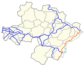
Freeway 4 (Arabic: طريق سريع ٤) is a freeway in Gandhara. The road runs from the Folkloria–Gandhara border through Sabbah, Farabi, and Bazegha, before ending at the Almarania–Gandhara border, covering a total of 740 km (460 mi). The entire freeway is part of Outernatian Highway 1.
The freeway consists of two multi-lane roadways, separated by a median. It has shoulders on the right side of both roadways. The general maximum speed limit is 120 km/h (75 mph), but certain parts of the road have a speed limit of 100 km/h (62 mph).