Aonach: Difference between revisions
No edit summary |
No edit summary |
||
| Line 87: | Line 87: | ||
'''Aonach''', officially the '''Democratic Republic of Aonach''', is a sovereign nation in South Internatia. Its mainland is bordered to the North and East by [[DPR Jindalea]], to the West by [[Canedonia]] and to the South by the Cold Sea. It also completely surrounds the nation of [[Swelatie]]. | '''Aonach''', officially the '''Democratic Republic of Aonach''', is a sovereign nation in South Internatia. Its mainland is bordered to the North and East by [[DPR Jindalea]], to the West by [[Canedonia]] and to the South by the Cold Sea. It also completely surrounds the nation of [[Swelatie]]. | ||
Aonach is a constitutional democracy organized in the form of a parliamentary republic. It is a developed country with | Aonach is a constitutional democracy organized in the form of a parliamentary republic. It is a developed country with a large economy, and very high living standards. | ||
==Geography== | |||
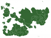
Aonach is a mountainous nation, with the highest peak being Mont Cnoc, located in the state of Átha, in the north of the nation. The height of this peak is 5486 ft or 1672.13 m. This peak is located in the '''Chaîne Sléibhte''', both the highest and longest range in the nation of Aonach. | |||
There are three major rivers located in the nation, and two of these are considered vital rivers in the southern region of Internatia. Both of these exit Internatia through Aonach (through Béál) and into the Southern Ocean, and are therefore crucial to the Aonachian economy. The longest river is the '''Gabhann''' river and Láirge is built on this. The length of the river is 512 km. | |||
As can be seen from the map, Átha lacks a major river in it's territory and as a result of the mountainous terrain and small size, it is the most sparsely populated state in Aonach. | |||
==Constituent states== | |||
Aonach comprises of four states. Each state has its own state constitution and is largely autonomous in regard to its internal organization. | |||
{| style="clear:both" class="sortable wikitable" | |||
|- style="background:#bbb" | |||
! class="unsortable" style="width:50px" | Flag | |||
! State | |||
! Area (km²) | |||
! Population | |||
! Pop.<br />per km² | |||
! Capital | |||
|- style="background:#eee" | |||
|[[File:Flag of Árann.png|100px]] | |||
|[[Árann]] | |||
|142100 | |||
|4,450,000 | |||
|31.35 | |||
|Saint-Germain | |||
|- style="background: #ddd" | |||
|[[File:Flag of Átha.png|100px]] | |||
|[[Átha]] | |||
|60207 | |||
|850,000 | |||
|14.12 | |||
|Gheimhridh | |||
|- style="background:#eee" | |||
|[[File:Flag of Béál.png|100px]] | |||
|[[Béal]] | |||
|171250 | |||
|7,500,000 | |||
|43.79 | |||
|Láirge | |||
|- style="background: #ddd" | |||
|[[File:Flag of Morsa.png|100px]] | |||
|[[Morsa]] | |||
|76800 | |||
|1,750,000 | |||
|22.79 | |||
|Billancourt | |||
|} | |||
Revision as of 14:26, 16 June 2013
| Democratic Republic of Aonach Aonach | |
|---|---|
 Flag | |
 Location of Aonach in Internatia. | |
| Capital and largest city | Láirge |
| Official languages | Aonachian, French and English |
| Demonym | Aonachian |
| Government | Constitutional Democracy |
| Republic Formed 20th century (1992) | |
| Area | |
• Total | 450,217 km2 (173,830 sq mi) |
| Population | |
• 2013 estimate | 14,514,670 |
• Density | 32.29/km2 (83.6/sq mi) |
| Currency | Schilling (AOS) |
| Time zone | FIT (UTC+3:00) |
| Date format | DD/MM/YY |
| Drives on the | left |
| Calling code | 57 |
| Internet TLD | .ac |
Aonach, officially the Democratic Republic of Aonach, is a sovereign nation in South Internatia. Its mainland is bordered to the North and East by DPR Jindalea, to the West by Canedonia and to the South by the Cold Sea. It also completely surrounds the nation of Swelatie.
Aonach is a constitutional democracy organized in the form of a parliamentary republic. It is a developed country with a large economy, and very high living standards.
Geography
Aonach is a mountainous nation, with the highest peak being Mont Cnoc, located in the state of Átha, in the north of the nation. The height of this peak is 5486 ft or 1672.13 m. This peak is located in the Chaîne Sléibhte, both the highest and longest range in the nation of Aonach.
There are three major rivers located in the nation, and two of these are considered vital rivers in the southern region of Internatia. Both of these exit Internatia through Aonach (through Béál) and into the Southern Ocean, and are therefore crucial to the Aonachian economy. The longest river is the Gabhann river and Láirge is built on this. The length of the river is 512 km.
As can be seen from the map, Átha lacks a major river in it's territory and as a result of the mountainous terrain and small size, it is the most sparsely populated state in Aonach.
Constituent states
Aonach comprises of four states. Each state has its own state constitution and is largely autonomous in regard to its internal organization.
| Flag | State | Area (km²) | Population | Pop. per km² |
Capital |
|---|---|---|---|---|---|

|
Árann | 142100 | 4,450,000 | 31.35 | Saint-Germain |

|
Átha | 60207 | 850,000 | 14.12 | Gheimhridh |
| File:Flag of Béál.png | Béal | 171250 | 7,500,000 | 43.79 | Láirge |

|
Morsa | 76800 | 1,750,000 | 22.79 | Billancourt |
| Sovereign states |
|  |
|---|---|---|
| Extracontinental states | ||
| Other states | ||
| Former states |
| |