Outernatian Highway 1: Difference between revisions
Created page with "{{Infobox | name = | title = | bodystyle = width:300px; font-size:90%; padding:0 | abovestyle = | above = Outernatian Highway 1 | titlestyle = | image..." |
No edit summary |
||
| Line 8: | Line 8: | ||
| imageclass = | | imageclass = | ||
| imagestyle = | | imagestyle = | ||
| image = [[File:Outernatian Highway 1 route.png|290px]] | | image = [[File:Outernatian Highway 1 sign.png|120px]]<br>[[File:Outernatian Highway 1 route.png|290px]] | ||
| headerstyle = background:#003e89 | | headerstyle = background:#003e89 | ||
| labelstyle = | | labelstyle = | ||
Latest revision as of 18:04, 3 September 2016
| Outernatian Highway 1 | |
|---|---|
  | |
| Major junctions | |
| East end: | Nordfjord, Kimmystan |
| West End: | Hugo Chávez City, Lettuce |
| Location | |
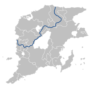
| Countries: | Nordfjord, Kimmystan via Monteverde, Xara Khanate, Folkloria, Gandhara, Almarania, Frostfall, and Raingate to Hugo Chávez City, Lettuce |
Outernatian Highway 1 (OH1) is a route of the Outernatian Highway Network, running 5,756 km (3,577 mi) from Nordfjord, Kimmystan via Monteverde, Xara Khanate, Folkloria, Gandhara, Almarania, Frostfall, and Raingate to Hugo Chávez City, Lettuce.
