Almarania: Difference between revisions
No edit summary |
|||
| (24 intermediate revisions by the same user not shown) | |||
| Line 85: | Line 85: | ||
|}} | |}} | ||
'''Almarania''' ([[wikipedia:language|Almaranian]]: ''Almaranija'', [[wikipedia:German language|German]]: ''Almaranien'', [[wikipedia: | '''Almarania''' ([[wikipedia:language|Almaranian]]: ''Almaranija'', [[wikipedia:German language|German]]: ''Almaranien'', [[wikipedia:Italian language|Italian]]: ''Almarania''), officially the '''United States of Almarania''' ([[wikipedia:language|Almaranian]]: ''Ujedineni štati almaranjske, UŠA'') is a country in the southeastern part of [[Outernatia]]. Covering a territory of 872,315 km<sup>2</sup> it is among the biggest countries on the continent, bordering [[Gandhara]] to the northwest, [[Polland]] to the southwest and six [[wikipedia:barbarians|Barbarian territories]]. To the south lies the Southern Ocean and to the north the country borders the [[Nuran Sea]] (Almaranian: ''Morje polnočne''). Its capital is [[Saída]]. It is divided into 16 states and two cities with special status. As of 2014, the population of Almarania accounts for 72,888,000 people. | ||
The Almaranian statehood dates back to the 7th century CE with the [[wikipedia:state|State of Bogdan]] along the banks of the Caspian Sea, some of its territory is now located in Gandhara. In 1428, Almarania and neighbouring | The Almaranian statehood dates back to the 7th century CE with the [[wikipedia:state|State of Bogdan]] along the banks of the Caspian Sea, some of its territory is now located in Gandhara. In 1428, Almarania and neighbouring Polland created the [[wikipedia:commonwealth|Southern Commonwealth]], a [[wikipedia:personal union|personal union]] between the two states, which became a major political factor in Outernatia up until the 18th century. In the late 18th century the Commonwealth was partitioned between [[Jindalea|Kingdom of Jindalea]], [[Democratic People's Republic of United Sunetti|Sunetti]] and [[St Olaf]], who all had colonizing interests in Outernatia. Most of Almarania proper was located in the Sibinian territory, only with a small part in the west that was originally Sunettian. The northern part of Almarania, with Saída as a capital, became independent in 1912. The southern regions though, with the thriving port city of Sylvestria as an administrative center, did not renounce Olaf Minnesotan rule and rejoin Almarania up until 1975. | ||
As of now, Almarania has a high-income market economy, and scores "very high" on the Human Development Index. The abundance of natural resources and the rapidly growing economy make some scholars to refer to Almarania as a "superpower in the making". It is a founding member of the [[Council of Outernatia]]. | As of now, Almarania has a high-income market economy, and scores "very high" on the Human Development Index. The abundance of natural resources and the rapidly growing economy make some scholars to refer to Almarania as a "superpower in the making". It is a founding member of the [[Council of Outernatia]]. | ||
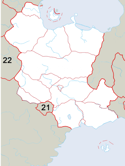
== Administrative divisions == | |||
{{Image label begin|image=Provinces of Almarania.png||link=|width={{{width|400}}}|float={{{float|none}}}}} | |||
{{Image label small|x=0.17|y=0.28|scale={{{width|400}}}|text=[[Polesje]]}} | |||
{{Image label small|x=0.23|y=0.09|scale={{{width|400}}}|text=[[Mavrija]]}} | |||
{{Image label small|x=0.61|y=0.32|scale={{{width|400}}}|text=[[Laguna (state)|Laguna]]}} | |||
{{Image label small|x=0.38|y=0.37|scale={{{width|400}}}|text=[[Porojna]]}} | |||
{{Image label small|x=0.40|y=0.16|scale={{{width|400}}}|text=[[Siniša]]}} | |||
{{Image label small|x=0.38|y=0.52|scale={{{width|400}}}|text=[[Upper Almarania]]}} | |||
{{Image label small|x=0.35|y=0.66|scale={{{width|400}}}|text=[[Magura]]}} | |||
{{Image label small|x=0.55|y=0.74|scale={{{width|400}}}|text=[[Lower Almarania|Lower<br />Almarania]]}} | |||
{{Image label small|x=0.70|y=0.95|scale={{{width|400}}}|text=[[East Pomorska]]}} | |||
{{Image label small|x=0.76|y=0.80|scale={{{width|400}}}|text=[[Vinjarska]]}} | |||
{{Image label small|x=0.50|y=0.92|scale={{{width|400}}}|text=[[West Pomorska|West<br />Pomorska]]}} | |||
{{Image label small|x=0.18|y=0.81|scale={{{width|400}}}|text=[[Mostovica]]}} | |||
{{Image label small|x=0.79|y=1.26|scale={{{width|400}}}|text=[[Camorran Islands|Camorran<br />Islands]]}} | |||
{{Image label small|x=0.23|y=0.72|scale={{{width|400}}}|text=[[Zlatozem]]}} | |||
{{Image label small|x=0.47|y=0.71|scale={{{width|400}}}|text=[[Saída]]}} | |||
{{Image label small|x=0.60|y=0.99|scale={{{width|400}}}|text=[[Sylvestria]]}} | |||
{{Image label end}} | |||
=== States === | |||
{| border="1" cellspacing="1" cellpadding="4" style="wikitable sortable; background:#ffffff;" | |||
|- bgcolor="#f0f0f0" | |||
! Flag !! State !! Capital !! Area !! Population | |||
|- | |||
| [[File:Flag_of_Camorrans.png|70px]] || [[Camorran Islands]] || [[Altimira]] ||3,303 km<sup>2</sup> ||align=right| 73,400 | |||
|- | |||
| [[File:Flag_of_East_Pomorska.png|70px]] || [[East Pomorska]] || [[Simljan]] ||94,207 km<sup>2</sup> ||align=right| 73,400 | |||
|- | |||
| [[File:Flag_of_Laguna.png|70px]] || [[Laguna (state)|Laguna]] || [[Tihum]] ||126,560 km<sup>2</sup> ||align=right| 4,214,503 | |||
|- | |||
| [[File:Flag_of_Lower_Almarania.png|70px]] || [[Lower Almarania]] || [[Bjelašin]] ||123,837 km<sup>2</sup> ||align=right| 9,795,819 | |||
|- | |||
| [[File:Flag_of_Magura.png|70px]] || [[Magura]] || [[Preblatin]] ||27,811 km<sup>2</sup> ||align=right| 4,385,992 | |||
|- | |||
| [[File:Flag_of_Mavrija.png|70px]] || [[Mavrija]] || [[Timur]] ||27,349 km<sup>2</sup> ||align=right| 2,704,995 | |||
|- | |||
| [[File:Flag_of_Mostovica.png|70px]] || [[Mostovica]] || [[Poligor]] ||23,474 km<sup>2</sup> ||align=right| 1,825,940 | |||
|- | |||
| [[File:Flag_of_Upper_Almarania.png|70px]] || [[Upper Almarania]] || [[Lovčan]] ||232,675 km<sup>2</sup> ||align=right| 2,603,890 | |||
|- | |||
| [[File:Flag_of_Polesje.png|70px]] || [[Polesje]] || [[Arabella]] ||157,460 km<sup>2</sup> ||align=right| 7,323,520 | |||
|- | |||
| [[File:Flag_of_Porojna.png|70px]] || [[Porojna]] || [[Karamančin]] ||119,969 km<sup>2</sup> ||align=right| 7,323,520 | |||
|- | |||
| [[File:Flag_of_Porojna.png|70px]] || [[Siniša]] || [[Prizrak]] ||7,969 km<sup>2</sup> ||align=right| 7,323,520 | |||
|- | |||
| [[File:Flag_of_Vinjarska.png|70px]] || [[Vinjarska]] || [[Uslanj]] ||69,194 km<sup>2</sup> ||align=right| 7,323,520 | |||
|- | |||
| [[File:Flag_of_West_Pomorska.png|70px]] || [[West Pomorska]] || [[Kobarid]] ||86,721 km<sup>2</sup> ||align=right| 7,323,520 | |||
|- | |||
| [[File:Flag_of_Zlatozem.png|70px]] || [[Zlatozem]] || [[Jařník]] ||81,012 km<sup>2</sup> ||align=right| 7,323,520 | |||
|}<noinclude> | |||
=== Cities with special status === | |||
{| border="1" cellspacing="1" cellpadding="4" style="wikitable sortable; background:#ffffff;" | |||
|- bgcolor="#f0f0f0" | |||
! Flag !! Coat of arms !! City !! Area !! Population | |||
|- | |||
| [[File:Flag_of_Saída.png|70px]] || <center>[[File:Coat_of_arms_of_Saída.png|60px]]</center> || [[Saída]] ||2,623 km<sup>2</sup> ||align=right| 3,478,291 | |||
|- | |||
| [[File:Flag_of_Sylvestria.png|70px]] || <center>[[File:Coat_of_arms_of_Sylvestria.png|60px]]</center> || [[Sylvestria]] ||2,789 km<sup>2</sup> ||align=right| 2,675,310 | |||
|}<noinclude> | |||
== Cities == | == Cities == | ||
| Line 110: | Line 178: | ||
| city_4 = Šimljan | div_4 = West Pomorska | pop_4 = 1,330,117 | img_4 = BCN01.JPG | | city_4 = Šimljan | div_4 = West Pomorska | pop_4 = 1,330,117 | img_4 = BCN01.JPG | ||
| city_5 = Kobarid | div_5 = East Pomorska | pop_5 = 1,003,204 | | city_5 = Kobarid | div_5 = East Pomorska | pop_5 = 1,003,204 | ||
| city_6 = Košulj | div_6 = | | city_6 = Košulj | div_6 = Lower Almarania | pop_6 = 913,745 | ||
| city_7 = Čaplen | div_7 = Polesje | pop_7 = 828,694 | | city_7 = Čaplen | div_7 = Polesje | pop_7 = 828,694 | ||
| city_8 = Bjelašin | div_8 = | | city_8 = Bjelašin | div_8 = Lower Almarania | pop_8 = 785,200 | ||
| city_9 = Lovčan | div_9 = Nagorje | pop_9 = 723,000 | | city_9 = Lovčan | div_9 = Nagorje | pop_9 = 723,000 | ||
| city_10 = Timur | div_10 = Mavrija | pop_10 = 705,300 | | city_10 = Timur | div_10 = Mavrija | pop_10 = 705,300 | ||
| city_11 = Karamančin | div_11 = Porojna | pop_11 = 379,820 | | city_11 = Karamančin | div_11 = Porojna | pop_11 = 379,820 | ||
| city_12 = Poligor | div_12 = Mostovica | pop_12 = 310,467 | | city_12 = Poligor | div_12 = Mostovica | pop_12 = 310,467 | ||
| city_13 = Jařník | div_13 = | | city_13 = Jařník | div_13 = Zlatozem | pop_13 = 263,820 | ||
| city_14 = Preblatin | div_14 = Magura | pop_14 = 254,790 | | city_14 = Preblatin | div_14 = Magura | pop_14 = 254,790 | ||
| city_15 = Pušlar | div_15 = Magura | pop_15 = 237,889 | | city_15 = Pušlar | div_15 = Magura | pop_15 = 237,889 | ||
| city_16 = Grančin | div_16 = Polesje | pop_16 = 231,880 | | city_16 = Grančin | div_16 = Polesje | pop_16 = 231,880 | ||
| city_17 = Uslanj | div_17 = Vinjarska | pop_17 = 211,130 | | city_17 = Uslanj | div_17 = Vinjarska | pop_17 = 211,130 | ||
| city_18 = Šilentau | div_18 = Laguna | pop_18 = 211,108 | | city_18 = Šilentau | div_18 = Laguna (state){{!}}Laguna | pop_18 = 211,108 | ||
| city_19 = Prizrak | div_19 = Siniša | pop_19 = 201,204 | | city_19 = Prizrak | div_19 = Siniša | pop_19 = 201,204 | ||
| city_20 = Korublja | div_20 = | | city_20 = Korublja | div_20 = Lower Almarania | pop_20 = 197,123 | ||
}} | }} | ||
== See also == | |||
* [[Mavrija dispute]] | |||
[[Category:Country]] | [[Category:Country]] | ||
Latest revision as of 18:31, 6 June 2015
United States of Almarania | |
|---|---|
 Flag | |
Motto: Semper fidelis (Latin) Always faithful | |
Anthem: Jasna mesečina (Almaranian) A Bright Moon | |
 Location of Almarania in Outernatia | |
| Capital and largest city | Saída |
| Official languages | Almaranian |
| Recognised regional languages | |
| Ethnic groups |
|
| Demonym | Gandhari |
| Government | Federal presidential republic |
| Alexander Lidovský | |
• Vice-President | Mirela Winterheim |
• Chairman of Parliament | Borislav Timočan |
| Area | |
• Total | 1,198,091 km2 (462,586 sq mi) |
| Population | |
• 2012 estimate | 72,888,000 |
• Density | 60.8/km2 (157.5/sq mi) |
| Currency | Almaranian pinta (ALP) |
| Date format | DD/MM/YYYY |
| Drives on the | right |
| Calling code | 872 |
| Internet TLD | .al |
Almarania (Almaranian: Almaranija, German: Almaranien, Italian: Almarania), officially the United States of Almarania (Almaranian: Ujedineni štati almaranjske, UŠA) is a country in the southeastern part of Outernatia. Covering a territory of 872,315 km2 it is among the biggest countries on the continent, bordering Gandhara to the northwest, Polland to the southwest and six Barbarian territories. To the south lies the Southern Ocean and to the north the country borders the Nuran Sea (Almaranian: Morje polnočne). Its capital is Saída. It is divided into 16 states and two cities with special status. As of 2014, the population of Almarania accounts for 72,888,000 people.
The Almaranian statehood dates back to the 7th century CE with the State of Bogdan along the banks of the Caspian Sea, some of its territory is now located in Gandhara. In 1428, Almarania and neighbouring Polland created the Southern Commonwealth, a personal union between the two states, which became a major political factor in Outernatia up until the 18th century. In the late 18th century the Commonwealth was partitioned between Kingdom of Jindalea, Sunetti and St Olaf, who all had colonizing interests in Outernatia. Most of Almarania proper was located in the Sibinian territory, only with a small part in the west that was originally Sunettian. The northern part of Almarania, with Saída as a capital, became independent in 1912. The southern regions though, with the thriving port city of Sylvestria as an administrative center, did not renounce Olaf Minnesotan rule and rejoin Almarania up until 1975.
As of now, Almarania has a high-income market economy, and scores "very high" on the Human Development Index. The abundance of natural resources and the rapidly growing economy make some scholars to refer to Almarania as a "superpower in the making". It is a founding member of the Council of Outernatia.
Administrative divisions
States
| Flag | State | Capital | Area | Population |
|---|---|---|---|---|
| File:Flag of Camorrans.png | Camorran Islands | Altimira | 3,303 km2 | 73,400 |
| File:Flag of East Pomorska.png | East Pomorska | Simljan | 94,207 km2 | 73,400 |
| Laguna | Tihum | 126,560 km2 | 4,214,503 | |
| File:Flag of Lower Almarania.png | Lower Almarania | Bjelašin | 123,837 km2 | 9,795,819 |
| File:Flag of Magura.png | Magura | Preblatin | 27,811 km2 | 4,385,992 |
| Mavrija | Timur | 27,349 km2 | 2,704,995 | |
| File:Flag of Mostovica.png | Mostovica | Poligor | 23,474 km2 | 1,825,940 |
| File:Flag of Upper Almarania.png | Upper Almarania | Lovčan | 232,675 km2 | 2,603,890 |
| File:Flag of Polesje.png | Polesje | Arabella | 157,460 km2 | 7,323,520 |
| File:Flag of Porojna.png | Porojna | Karamančin | 119,969 km2 | 7,323,520 |
| File:Flag of Porojna.png | Siniša | Prizrak | 7,969 km2 | 7,323,520 |
| File:Flag of Vinjarska.png | Vinjarska | Uslanj | 69,194 km2 | 7,323,520 |
| File:Flag of West Pomorska.png | West Pomorska | Kobarid | 86,721 km2 | 7,323,520 |
| File:Flag of Zlatozem.png | Zlatozem | Jařník | 81,012 km2 | 7,323,520 |
Cities with special status
| Flag | Coat of arms | City | Area | Population |
|---|---|---|---|---|
 |
Saída | 2,623 km2 | 3,478,291 | |
| Sylvestria | 2,789 km2 | 2,675,310 |
Cities
Largest cities or towns in Almarania
Almaranjski institut statistični (AIS) | |||||||||
|---|---|---|---|---|---|---|---|---|---|
| [[1]] | States of Almarania | [Pop.] | [[2]] | States of Almarania | [Pop.] | ||||
 Saída  Sylvestria |
1 | Saída | Special status | 2,892,318 | 11 | Karamančin | Porojna | 379,820 |  Tihum  Šimljan |
| 2 | Sylvestria | Special status | 2,613,532 | 12 | Poligor | Mostovica | 310,467 | ||
| 3 | Tihum | Laguna | 1,629,850 | 13 | Jařník | Zlatozem | 263,820 | ||
| 4 | Šimljan | West Pomorska | 1,330,117 | 14 | Preblatin | Magura | 254,790 | ||
| 5 | Kobarid | East Pomorska | 1,003,204 | 15 | Pušlar | Magura | 237,889 | ||
| 6 | Košulj | Lower Almarania | 913,745 | 16 | Grančin | Polesje | 231,880 | ||
| 7 | Čaplen | Polesje | 828,694 | 17 | Uslanj | Vinjarska | 211,130 | ||
| 8 | Bjelašin | Lower Almarania | 785,200 | 18 | Šilentau | Laguna | 211,108 | ||
| 9 | Lovčan | Nagorje | 723,000 | 19 | Prizrak | Siniša | 201,204 | ||
| 10 | Timur | Mavrija | 705,300 | 20 | Korublja | Lower Almarania | 197,123 | ||