Socialist Republic of Yazminia: Difference between revisions
Jump to navigation
Jump to search
m (Liech moved page Socialist Republic of Yazminia to SR of Yazminia) |
m (Liech moved page SR of Yazminia to Socialist Republic of Yazminia over redirect) |
(No difference)
| |
Revision as of 03:46, 8 December 2012
| Socialist Republic of Yazminia Socialisma Respubliko de Yazminia | |
  | |
One for all | |
Be glorious, our free motherland! | |

| |
| Capital (and largest city) |
Liechgrad |
| Official languages | Yazminian |
| Ethnic groups |
87% Yazminians 13% Foreigners |
| Government — President — Prime Minister |
Socialist state and multi-party system Karlo Marso Leviĝis Luksemburgio |
| Legislature |
Popola Domo |
| Formation — The Union |
1368 |
| Area — Total — Marine |
456,283 km² (148 368 sq mi) 4% |
| Population — 2012 estimate |
41,339,210 90.6 persons / sq km 234.7 persons / sq mi |
| GDP (PPP, 2012) — Total ($) — GDP/capita ($) |
30,412 |
| GDP (Nominal, 2012) — Total ($) — GDP/capita ($) |
28,976 |
| HDI rating (2012) | |
| Gini coefficient (2012) | |
| Currency | Yazminian ruble (¥) (YZR) |
| Time zone | GMT (UTC-04:00) |
| Time format | 24-hour clock (00:00—23:59) |
| Date format | dd-mm-yyyy |
| Drives on the | right |
| Internet TLD | .yz |
| Calling code | +43 |
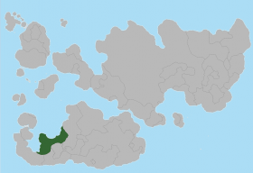
Yazminia, officially the The Socialist Republic of Yazminia (Yazminian: Socialisma Respubliko de Yazminia) is a state located in the north of Southern Internalia. Its territory extends by the Yazminian peninsula and adjacent lands along the southeast of the Algasorian bay coast with a total area of 456,282 km2 and 41,339,210 people living in. Yazminia borders to the southwest with Dimkarus, to the south with Nicolas' Neighbour and the Land 42 and to the east with Grolskira.
Yazminia is organized as a multi-party system within a socialist state. It is a developed country, is one of the countries with less inequality according to the OECD and it has the "very high living standards" label given by UNDP.
Administrative divisions
| Region | Capital | Population | Area | Density | |
|---|---|---|---|---|---|
| Anatia | Naskiganta Suno | ||||
| A Rabi | Konstela | ||||
| Calaf | Dukoj Amikia | ||||
| Englia | Urbo de Popola | ||||
| Komunia | Remeria | ||||
| Liechgrad | Liechgrad | ||||
| Mezo | Gaulia | ||||
| Nigra Lando | O Mantelo | ||||
| Sunsubiro | Platinia | ||||
| Tera de Feina | Maro |
