Hare Krishna: Difference between revisions
Jump to navigation
Jump to search
No edit summary |
No edit summary |
||
| Line 24: | Line 24: | ||
| header6 = | | header6 = | ||
| label6 = Countries | | label6 = Countries | ||
| data6 = {{Collapsible list |title=List| |{{flag|Almarania}} |{{flag|Frostfall}} |{{flag|Gandhara}} |{{flag|Raingate}} |{{flag|Sofós}} |{{flag|Zelmerlöwia}}}} | | data6 = {{Collapsible list |title=List| |{{flag|Almarania}} |{{flag|Folkloria}} |{{flag|Frostfall}} |{{flag|Gandhara}} |{{flag|Raingate}} |{{flag|Sofós}} |{{flag|Zelmerlöwia}}}} | ||
| header7 = | | header7 = | ||
| label7 = Region | | label7 = Region | ||
| Line 30: | Line 30: | ||
}} | }} | ||
The '''Hare Krishna''' ([[Wikipedia:Arabic|Arabic]]: هاري كريشنا) is a [[Wikipedia:Mountain_range|mountain range]] on the eastern landmass of [[Outernatia]]. It is mostly located in [[Gandhara]], but it also spans | The '''Hare Krishna''' ([[Wikipedia:Arabic|Arabic]]: هاري كريشنا) is a [[Wikipedia:Mountain_range|mountain range]] on the eastern landmass of [[Outernatia]]. It is mostly located in [[Gandhara]], but it also spans six other countries: [[Almarania]], [[Folkloria]], [[Frostfall]], [[Raingate]], [[Sofós]], and [[Zelmerlöwia]]. | ||
The highest point in the Hare Krishna is [[Mount Taysir]] at 5,769 metres (18,927 ft) in the [[Qumi Governorate]] in Gandhara. To the east, the Hare Krishna stretches through eastern Gandhara, | The highest point in the Hare Krishna is [[Mount Taysir]] at 5,769 metres (18,927 ft) in the [[Qumi Governorate]] in Gandhara. To the east, the Hare Krishna stretches through eastern Gandhara, with a small portion located in Folkloria. From the north, the mountain range runs from Sofós through central Gandhara, after which it runs through the Raingatian provinces [[The Rift]], [[The Vale]], and [[High Rock]], finally merging into minor ranges in Almarania and Frostfall. | ||
[[Category:Hare Krishna]] | [[Category:Hare Krishna]] | ||
[[Category:Mountain ranges of Outernatia]] | [[Category:Mountain ranges of Outernatia]] | ||
Latest revision as of 20:06, 20 April 2016
| Hare Krishna | |
|---|---|
 Aerial view of the Hare Krishna range | |
| Highest point | |
| Peak | Mount Taysir |
| Elevation | 5,769 m (18,927 ft) |
| Geography | |
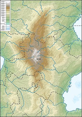
 Topographic map | |
| Countries | |
| Region | Eastern Outernatia |
The Hare Krishna (Arabic: هاري كريشنا) is a mountain range on the eastern landmass of Outernatia. It is mostly located in Gandhara, but it also spans six other countries: Almarania, Folkloria, Frostfall, Raingate, Sofós, and Zelmerlöwia.
The highest point in the Hare Krishna is Mount Taysir at 5,769 metres (18,927 ft) in the Qumi Governorate in Gandhara. To the east, the Hare Krishna stretches through eastern Gandhara, with a small portion located in Folkloria. From the north, the mountain range runs from Sofós through central Gandhara, after which it runs through the Raingatian provinces The Rift, The Vale, and High Rock, finally merging into minor ranges in Almarania and Frostfall.