Template:Infobox country/testcases
| This is the template test case page for the sandbox of Template:Infobox country. to update the examples. If there are many examples of a complicated template, later ones may break due to limits in MediaWiki, see the HTML comment "NewPP limit report" in the rendered page. You can also use Special:ExpandTemplates to examine the results of template uses. You can test how this page looks in the different skins with these links: |
| {{Infobox country}} | {{Infobox country/sandbox}} | ||||||||||||||||||||||||||||||||||||||||||||||||||||||||||||||||||||||||||||||||||||||||||||||||||||||||||||||||||||||||||||||||||||||||||||||||||||||||||||||||||||||||||||||||||||||||||||||||||||||||||||||||||||||
|---|---|---|---|---|---|---|---|---|---|---|---|---|---|---|---|---|---|---|---|---|---|---|---|---|---|---|---|---|---|---|---|---|---|---|---|---|---|---|---|---|---|---|---|---|---|---|---|---|---|---|---|---|---|---|---|---|---|---|---|---|---|---|---|---|---|---|---|---|---|---|---|---|---|---|---|---|---|---|---|---|---|---|---|---|---|---|---|---|---|---|---|---|---|---|---|---|---|---|---|---|---|---|---|---|---|---|---|---|---|---|---|---|---|---|---|---|---|---|---|---|---|---|---|---|---|---|---|---|---|---|---|---|---|---|---|---|---|---|---|---|---|---|---|---|---|---|---|---|---|---|---|---|---|---|---|---|---|---|---|---|---|---|---|---|---|---|---|---|---|---|---|---|---|---|---|---|---|---|---|---|---|---|---|---|---|---|---|---|---|---|---|---|---|---|---|---|---|---|---|---|---|---|---|---|---|---|---|---|---|---|---|---|---|---|---|
|
| ||||||||||||||||||||||||||||||||||||||||||||||||||||||||||||||||||||||||||||||||||||||||||||||||||||||||||||||||||||||||||||||||||||||||||||||||||||||||||||||||||||||||||||||||||||||||||||||||||||||||||||||||||||||
| {{Infobox country}} | {{Infobox country/sandbox}} | |||||||||||||||||||||||||||||||||||||||||||||||||||||||||||||||||||||||||||||||||||||||||||||||||||||||||||||||||||||||||||||||||||||||||||||||||||||||||||||||||||||||||||||||||||||||||||||||||||||||||||||||||||||||||||||||||||||
|---|---|---|---|---|---|---|---|---|---|---|---|---|---|---|---|---|---|---|---|---|---|---|---|---|---|---|---|---|---|---|---|---|---|---|---|---|---|---|---|---|---|---|---|---|---|---|---|---|---|---|---|---|---|---|---|---|---|---|---|---|---|---|---|---|---|---|---|---|---|---|---|---|---|---|---|---|---|---|---|---|---|---|---|---|---|---|---|---|---|---|---|---|---|---|---|---|---|---|---|---|---|---|---|---|---|---|---|---|---|---|---|---|---|---|---|---|---|---|---|---|---|---|---|---|---|---|---|---|---|---|---|---|---|---|---|---|---|---|---|---|---|---|---|---|---|---|---|---|---|---|---|---|---|---|---|---|---|---|---|---|---|---|---|---|---|---|---|---|---|---|---|---|---|---|---|---|---|---|---|---|---|---|---|---|---|---|---|---|---|---|---|---|---|---|---|---|---|---|---|---|---|---|---|---|---|---|---|---|---|---|---|---|---|---|---|---|---|---|---|---|---|---|---|---|---|---|---|---|---|---|
|
| |||||||||||||||||||||||||||||||||||||||||||||||||||||||||||||||||||||||||||||||||||||||||||||||||||||||||||||||||||||||||||||||||||||||||||||||||||||||||||||||||||||||||||||||||||||||||||||||||||||||||||||||||||||||||||||||||||||
| {{Infobox country}} | {{Infobox country/sandbox}} | ||||||||||||||||||||||||||||||||||||||||||||||||||||||||||||||||||||||||||||||||||||||||||||||||||||||||||||||||||||||||||||||||||||||||||||||||||||||||||||||||||||||||||||||||||||||||||||||||
|---|---|---|---|---|---|---|---|---|---|---|---|---|---|---|---|---|---|---|---|---|---|---|---|---|---|---|---|---|---|---|---|---|---|---|---|---|---|---|---|---|---|---|---|---|---|---|---|---|---|---|---|---|---|---|---|---|---|---|---|---|---|---|---|---|---|---|---|---|---|---|---|---|---|---|---|---|---|---|---|---|---|---|---|---|---|---|---|---|---|---|---|---|---|---|---|---|---|---|---|---|---|---|---|---|---|---|---|---|---|---|---|---|---|---|---|---|---|---|---|---|---|---|---|---|---|---|---|---|---|---|---|---|---|---|---|---|---|---|---|---|---|---|---|---|---|---|---|---|---|---|---|---|---|---|---|---|---|---|---|---|---|---|---|---|---|---|---|---|---|---|---|---|---|---|---|---|---|---|---|---|---|---|---|---|---|---|---|---|---|---|---|---|---|
|
| ||||||||||||||||||||||||||||||||||||||||||||||||||||||||||||||||||||||||||||||||||||||||||||||||||||||||||||||||||||||||||||||||||||||||||||||||||||||||||||||||||||||||||||||||||||||||||||||||
| {{Infobox country}} | {{Infobox country/sandbox}} | ||||||||||||||||||||||||||||||||||||||||||||||||||||||||||||||||||||||||||||||||||||||||||||||||||||||||||||||||||||||||||||||||||||||||||||||||||||||||||||||||||||||||||
|---|---|---|---|---|---|---|---|---|---|---|---|---|---|---|---|---|---|---|---|---|---|---|---|---|---|---|---|---|---|---|---|---|---|---|---|---|---|---|---|---|---|---|---|---|---|---|---|---|---|---|---|---|---|---|---|---|---|---|---|---|---|---|---|---|---|---|---|---|---|---|---|---|---|---|---|---|---|---|---|---|---|---|---|---|---|---|---|---|---|---|---|---|---|---|---|---|---|---|---|---|---|---|---|---|---|---|---|---|---|---|---|---|---|---|---|---|---|---|---|---|---|---|---|---|---|---|---|---|---|---|---|---|---|---|---|---|---|---|---|---|---|---|---|---|---|---|---|---|---|---|---|---|---|---|---|---|---|---|---|---|---|---|---|---|---|---|---|---|---|---|---|
|
| ||||||||||||||||||||||||||||||||||||||||||||||||||||||||||||||||||||||||||||||||||||||||||||||||||||||||||||||||||||||||||||||||||||||||||||||||||||||||||||||||||||||||||
| {{Infobox country}} | {{Infobox country/sandbox}} | ||||||||||||||||||||||||||||||||||||||||||||||||||||||||||||||||||||||||||||||||||||||||||||||||||||||||||||||||||||||||||||||||||||||||||||||||||||||||||||||||||||||||||||||||||||||||||||||||||||||||||||||||||||||||||||||||||||||||||
|---|---|---|---|---|---|---|---|---|---|---|---|---|---|---|---|---|---|---|---|---|---|---|---|---|---|---|---|---|---|---|---|---|---|---|---|---|---|---|---|---|---|---|---|---|---|---|---|---|---|---|---|---|---|---|---|---|---|---|---|---|---|---|---|---|---|---|---|---|---|---|---|---|---|---|---|---|---|---|---|---|---|---|---|---|---|---|---|---|---|---|---|---|---|---|---|---|---|---|---|---|---|---|---|---|---|---|---|---|---|---|---|---|---|---|---|---|---|---|---|---|---|---|---|---|---|---|---|---|---|---|---|---|---|---|---|---|---|---|---|---|---|---|---|---|---|---|---|---|---|---|---|---|---|---|---|---|---|---|---|---|---|---|---|---|---|---|---|---|---|---|---|---|---|---|---|---|---|---|---|---|---|---|---|---|---|---|---|---|---|---|---|---|---|---|---|---|---|---|---|---|---|---|---|---|---|---|---|---|---|---|---|---|---|---|---|---|---|---|---|---|---|---|---|---|---|---|---|---|---|---|---|---|---|---|---|
|
| ||||||||||||||||||||||||||||||||||||||||||||||||||||||||||||||||||||||||||||||||||||||||||||||||||||||||||||||||||||||||||||||||||||||||||||||||||||||||||||||||||||||||||||||||||||||||||||||||||||||||||||||||||||||||||||||||||||||||||
| {{Infobox country}} | {{Infobox country/sandbox}} | |||||||||||||||||||||||||||||||||||||||||||||||||||||||||||||||||||||||||||||||||||||||||||||||||||||||||||||||||||||||||||||||||||||||||||||||||||||||||||||||||||||||||||||||||||||||||||||||||||||||
|---|---|---|---|---|---|---|---|---|---|---|---|---|---|---|---|---|---|---|---|---|---|---|---|---|---|---|---|---|---|---|---|---|---|---|---|---|---|---|---|---|---|---|---|---|---|---|---|---|---|---|---|---|---|---|---|---|---|---|---|---|---|---|---|---|---|---|---|---|---|---|---|---|---|---|---|---|---|---|---|---|---|---|---|---|---|---|---|---|---|---|---|---|---|---|---|---|---|---|---|---|---|---|---|---|---|---|---|---|---|---|---|---|---|---|---|---|---|---|---|---|---|---|---|---|---|---|---|---|---|---|---|---|---|---|---|---|---|---|---|---|---|---|---|---|---|---|---|---|---|---|---|---|---|---|---|---|---|---|---|---|---|---|---|---|---|---|---|---|---|---|---|---|---|---|---|---|---|---|---|---|---|---|---|---|---|---|---|---|---|---|---|---|---|---|---|---|---|---|---|---|
|
| |||||||||||||||||||||||||||||||||||||||||||||||||||||||||||||||||||||||||||||||||||||||||||||||||||||||||||||||||||||||||||||||||||||||||||||||||||||||||||||||||||||||||||||||||||||||||||||||||||||||
| {{Infobox country}} | {{Infobox country/sandbox}} | |||||||||||||||||||||||||||||||||||||||||||||||||||||||||||||||||||||||||||||||||||||||||||||||||||||||||||||||||||||||||||||||||||||||||||||||||||||
|---|---|---|---|---|---|---|---|---|---|---|---|---|---|---|---|---|---|---|---|---|---|---|---|---|---|---|---|---|---|---|---|---|---|---|---|---|---|---|---|---|---|---|---|---|---|---|---|---|---|---|---|---|---|---|---|---|---|---|---|---|---|---|---|---|---|---|---|---|---|---|---|---|---|---|---|---|---|---|---|---|---|---|---|---|---|---|---|---|---|---|---|---|---|---|---|---|---|---|---|---|---|---|---|---|---|---|---|---|---|---|---|---|---|---|---|---|---|---|---|---|---|---|---|---|---|---|---|---|---|---|---|---|---|---|---|---|---|---|---|---|---|---|---|---|---|---|---|---|---|---|
|
| |||||||||||||||||||||||||||||||||||||||||||||||||||||||||||||||||||||||||||||||||||||||||||||||||||||||||||||||||||||||||||||||||||||||||||||||||||||
| {{Infobox country}} | {{Infobox country/sandbox}} | |||||||||||||||||||||||||||||||||||||||||||||||||||||||||||||||||||||||||||||||||||||||||||||||||||||||||||||
|---|---|---|---|---|---|---|---|---|---|---|---|---|---|---|---|---|---|---|---|---|---|---|---|---|---|---|---|---|---|---|---|---|---|---|---|---|---|---|---|---|---|---|---|---|---|---|---|---|---|---|---|---|---|---|---|---|---|---|---|---|---|---|---|---|---|---|---|---|---|---|---|---|---|---|---|---|---|---|---|---|---|---|---|---|---|---|---|---|---|---|---|---|---|---|---|---|---|---|---|---|---|---|---|---|---|---|---|---|---|---|
|
| |||||||||||||||||||||||||||||||||||||||||||||||||||||||||||||||||||||||||||||||||||||||||||||||||||||||||||||
OPEC
| {{Infobox geopolitical organization}} (redirects to {{Infobox country}}) |
{{Infobox country/sandbox}} | ||||||||||||||||||||||||||||||||||||||||||||||||||||||||||||||||||||||||||||||||||||||||||||
|---|---|---|---|---|---|---|---|---|---|---|---|---|---|---|---|---|---|---|---|---|---|---|---|---|---|---|---|---|---|---|---|---|---|---|---|---|---|---|---|---|---|---|---|---|---|---|---|---|---|---|---|---|---|---|---|---|---|---|---|---|---|---|---|---|---|---|---|---|---|---|---|---|---|---|---|---|---|---|---|---|---|---|---|---|---|---|---|---|---|---|---|---|---|
|
| ||||||||||||||||||||||||||||||||||||||||||||||||||||||||||||||||||||||||||||||||||||||||||||
Custom challenges
| {{Infobox country}} | {{Infobox country/sandbox}} | |||||||||||||||||||||||||||||||||||||||||||||||||||||||||||||||||||||||||||||||||||||||||||||||||||||||||||||||||||||||||||||||||||||||||||||||||||||||||||||||||||||||||||||||||||||||||||||||||||||||||||||||||||||||||||||||||||||||||||||||||||||||||||||||||||||||||||||||||||||||||||||||||||||||||||||||
|---|---|---|---|---|---|---|---|---|---|---|---|---|---|---|---|---|---|---|---|---|---|---|---|---|---|---|---|---|---|---|---|---|---|---|---|---|---|---|---|---|---|---|---|---|---|---|---|---|---|---|---|---|---|---|---|---|---|---|---|---|---|---|---|---|---|---|---|---|---|---|---|---|---|---|---|---|---|---|---|---|---|---|---|---|---|---|---|---|---|---|---|---|---|---|---|---|---|---|---|---|---|---|---|---|---|---|---|---|---|---|---|---|---|---|---|---|---|---|---|---|---|---|---|---|---|---|---|---|---|---|---|---|---|---|---|---|---|---|---|---|---|---|---|---|---|---|---|---|---|---|---|---|---|---|---|---|---|---|---|---|---|---|---|---|---|---|---|---|---|---|---|---|---|---|---|---|---|---|---|---|---|---|---|---|---|---|---|---|---|---|---|---|---|---|---|---|---|---|---|---|---|---|---|---|---|---|---|---|---|---|---|---|---|---|---|---|---|---|---|---|---|---|---|---|---|---|---|---|---|---|---|---|---|---|---|---|---|---|---|---|---|---|---|---|---|---|---|---|---|---|---|---|---|---|---|---|---|---|---|---|---|---|---|---|---|---|---|---|---|---|---|---|---|---|---|---|---|---|---|---|---|---|---|---|---|---|---|---|---|---|---|---|---|---|---|---|---|---|---|---|---|---|---|---|
|
<tr class="mergedbottomrow">
| |||||||||||||||||||||||||||||||||||||||||||||||||||||||||||||||||||||||||||||||||||||||||||||||||||||||||||||||||||||||||||||||||||||||||||||||||||||||||||||||||||||||||||||||||||||||||||||||||||||||||||||||||||||||||||||||||||||||||||||||||||||||||||||||||||||||||||||||||||||||||||||||||||||||||||||||
Just about every parameter (country/territory)
| {{Infobox country/sandbox}} | |||||||||||||||||||||||||||||||||||||||||||||||||||||||||||||||||||||||||||||||||||||||||||||||||||||||||||||||||||||||||||||||||||||||||||||||||||||||||||||||||||||||||||||||||||||||||||||||||||||||||||||||||||||||||||||||||||||||||||||||||||||||||||||||||||||||||||||||||||||||||||
|---|---|---|---|---|---|---|---|---|---|---|---|---|---|---|---|---|---|---|---|---|---|---|---|---|---|---|---|---|---|---|---|---|---|---|---|---|---|---|---|---|---|---|---|---|---|---|---|---|---|---|---|---|---|---|---|---|---|---|---|---|---|---|---|---|---|---|---|---|---|---|---|---|---|---|---|---|---|---|---|---|---|---|---|---|---|---|---|---|---|---|---|---|---|---|---|---|---|---|---|---|---|---|---|---|---|---|---|---|---|---|---|---|---|---|---|---|---|---|---|---|---|---|---|---|---|---|---|---|---|---|---|---|---|---|---|---|---|---|---|---|---|---|---|---|---|---|---|---|---|---|---|---|---|---|---|---|---|---|---|---|---|---|---|---|---|---|---|---|---|---|---|---|---|---|---|---|---|---|---|---|---|---|---|---|---|---|---|---|---|---|---|---|---|---|---|---|---|---|---|---|---|---|---|---|---|---|---|---|---|---|---|---|---|---|---|---|---|---|---|---|---|---|---|---|---|---|---|---|---|---|---|---|---|---|---|---|---|---|---|---|---|---|---|---|---|---|---|---|---|---|---|---|---|---|---|---|---|---|---|---|---|---|---|---|---|---|---|---|---|---|---|---|---|---|---|---|---|---|---|---|---|---|---|
<tr class="mergedbottomrow">
| |||||||||||||||||||||||||||||||||||||||||||||||||||||||||||||||||||||||||||||||||||||||||||||||||||||||||||||||||||||||||||||||||||||||||||||||||||||||||||||||||||||||||||||||||||||||||||||||||||||||||||||||||||||||||||||||||||||||||||||||||||||||||||||||||||||||||||||||||||||||||||
(References/notes)
- ^ a b c d Law of the People's Republic of China on the Standard Spoken and Written Chinese Language (Order of the President No.37)
- ^ a b "CONSTITUTION OF THE PEOPLE'S REPUBLIC OF CHINA". People's Daily Online. Retrieved 2009-11-23.
The People's Republic of China is a socialist state under the people's democratic dictatorship led by the working class and based on the alliance of workers and peasants.
- ^ "The role of the government, China". Encyclopaedia Britannica. http://www.britannica.com/eb/article-71005/China. Retrieved 2007-02-21.
- ^ a b Lua error: Internal error: The interpreter has terminated with signal "9".
- ^ Lua error: Internal error: The interpreter has terminated with signal "9".
- ^ Lua error: Internal error: The interpreter has terminated with signal "9".
- ^ CIA World Factbook [Gini rankings]
- ^ Human Development Report 2009. The United Nations. Retrieved 5 October 2009
- ^ Lua error: Internal error: The interpreter has terminated with signal "9".
- ^ "The role of the government, China". Encyclopaedia Britannica. http://www.britannica.com/eb/article-71005/China. Retrieved 2007-02-21.
- ^ Lua error: Internal error: The interpreter has terminated with signal "9".
- ^ Lua error: Internal error: The interpreter has terminated with signal "9".
- ^ CIA World Factbook [Gini rankings]
- ^ Human Development Report 2009. The United Nations. Retrieved 5 October 2009
- ^ Lua error: Internal error: The interpreter has terminated with signal "9".
- ^ Lua error: Internal error: The interpreter has terminated with signal "9".
- ^ Lua error: Internal error: The interpreter has terminated with signal "9".
- ^ Lua error: Internal error: The interpreter has terminated with signal "9".
- ^ Lua error: Internal error: The interpreter has terminated with signal "9".
- ^ Lua error: Internal error: The interpreter has terminated with signal "9".
- ^ a b Lua error: Internal error: The interpreter has terminated with signal "9".
- ^ Lua error: Internal error: The interpreter has terminated with signal "9"..
- ^ a b c d Lua error: Internal error: The interpreter has terminated with signal "9".
- ^ a b Lua error: Internal error: The interpreter has terminated with signal "9".
- ^ Lua error: Internal error: The interpreter has terminated with signal "9".
- ^ a b c d e f g h i j k l m n o p Lua error: Internal error: The interpreter has terminated with signal "9". Cite error: Invalid
<ref>tag; name "imf2" defined multiple times with different content - ^ a b Lua error: Internal error: The interpreter has terminated with signal "9".
- ^ Lua error: Internal error: The interpreter has terminated with signal "9".
- ^ Lua error: Internal error: The interpreter has terminated with signal "9".
- ^ Lua error: Internal error: The interpreter has terminated with signal "9".
- ^ Lua error: Internal error: The interpreter has terminated with signal "9".
- ^ Lua error: Internal error: The interpreter has terminated with signal "9".
- ^ Lua error: Internal error: The interpreter has terminated with signal "9".
- ^ Lua error: Internal error: The interpreter has terminated with signal "9"..
- ^ Lua error: Internal error: The interpreter has terminated with signal "9".
- ^ Lua error: Internal error: The interpreter has terminated with signal "9".
- ^ Extrapolation from U.S. POPClock. U.S. Census Bureau. Updated automatically.
- ^ a b c d Lua error: Internal error: The interpreter has terminated with signal "9".
- ^ Extrapolation from U.S. POPClock. U.S. Census Bureau. Updated automatically.
- ^ (French)Lua error: Internal error: The interpreter has terminated with signal "9". Lua error: Internal error: The interpreter has terminated with signal "9".
- ^ a b (French)Lua error: Internal error: The interpreter has terminated with signal "9". Lua error: Internal error: The interpreter has terminated with signal "9".
- ^ a b Lua error: Internal error: The interpreter has terminated with signal "9".
- ^ a b Lua error: Internal error: The interpreter has terminated with signal "9".
- ^ (French)Lua error: Internal error: The interpreter has terminated with signal "9". Lua error: Internal error: The interpreter has terminated with signal "9".
- ^ Lua error: Internal error: The interpreter has terminated with signal "9".
- ^ Lua error: Internal error: The interpreter has terminated with signal "9".
- ^ a b c d La Nouvelle-Calédonie se dote d'un hymne et d'une devise - LeMonde.fr
- ^ a b (French)Lua error: Internal error: The interpreter has terminated with signal "9". Lua error: Internal error: The interpreter has terminated with signal "9".
- ^ a b Population des communes et provinces de la Nouvelle-Calédonie de 1956 à 2009
- ^ a b c d [1]
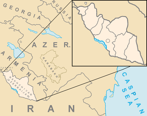
- ^ a b Official portal of Nakhchivan Autonomous Republic :Nakhchivan Autonomous Republic
- ^ a b Naxçıvan Muxtar Respublikası Nazirlər Kabinetinin 2012 Fevral Raportu
- ^ Chapter I, Article 6 of The Statute of the organization of the Petroleum Exporting Countries (as amended)
- ^ Chapter I, Article 6 of The Statute of the organization of the Petroleum Exporting Countries (as amended)
- ^ Lua error: Internal error: The interpreter has terminated with signal "9".
- ^ a b Lua error: Internal error: The interpreter has terminated with signal "9".
- ^ Lua error: Internal error: The interpreter has terminated with signal "9".
- Notes
- ^ French is an official language throughout the French Republic. For information about the official and unofficial regional languages also spoken see Languages of France
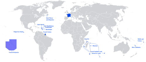
- ^ a b c d Including all the overseas departments but excluding overseas territories and the French territory of Terre Adélie in Antarctica where sovereignty is suspended since the signing of the Antarctic Treaty in 1959.
- ^ French National Geographic Institute data, which includes bodies of water.
- ^ French Land Register data, which exclude lakes, ponds and glaciers larger than 1 km² (0.386 sq mi or 247 acres) as well as the estuaries of rivers.
- ^ a b Metropolitan France only. The population density for the whole territory of the French Republic (including overseas departments and territories) is 96.837/km2 (250.808/sq mi).
- ^ Whole of the French Republic except the overseas territories in the Pacific Ocean.
- ^ French overseas territories in the Pacific Ocean only.
- ^ CET applies to Metropolitan France only. Time Zones across the French Republic span from UTC-10 (PF) to UTC+12 (WF).
- ^ CEST applies to Metropolitan France only. Not all overseas territories observe Daylight Saving Time.
- ^ The overseas regions and collectivities form part of the French telephone numbering plan, but have their own country calling codes: Guadeloupe +590; Martinique +596; French Guiana +594, Réunion and Mayotte +262; Saint Pierre and Miquelon +508. The overseas territories are not part of the French telephone numbering plan; their country calling codes are: New Caledonia +687, French Polynesia +689; Wallis and Futuna +681
- ^ In addition to .fr, several other Internet TLDs are used in French overseas départements and territories: .re, .mq, .gp, .tf, .nc, .pf, .wf, .pm, .gf and .yt. France also uses .eu, shared with other members of the European Union. The .cat domain is used in Catalan-speaking territories.
- ^ French is an official language throughout the French Republic. For information about the official and unofficial regional languages also spoken see Languages of France
- ^ French National Geographic Institute data, which includes bodies of water.
- ^ French Land Register data, which exclude lakes, ponds and glaciers larger than 1 km² (0.386 sq mi or 247 acres) as well as the estuaries of rivers.
- ^ Whole of the French Republic except the overseas territories in the Pacific Ocean.
- ^ French overseas territories in the Pacific Ocean only.
- ^ CET applies to Metropolitan France only. Time Zones across the French Republic span from UTC-10 (PF) to UTC+12 (WF).
- ^ CEST applies to Metropolitan France only. Not all overseas territories observe Daylight Saving Time.
- ^ The overseas regions and collectivities form part of the French telephone numbering plan, but have their own country calling codes: Guadeloupe +590; Martinique +596; French Guiana +594, Réunion and Mayotte +262; Saint Pierre and Miquelon +508. The overseas territories are not part of the French telephone numbering plan; their country calling codes are: New Caledonia +687, French Polynesia +689; Wallis and Futuna +681
- ^ In addition to .fr, several other Internet TLDs are used in French overseas départements and territories: .re, .mq, .gp, .tf, .nc, .pf, .wf, .pm, .gf and .yt. France also uses .eu, shared with other members of the European Union. The .cat domain is used in Catalan-speaking territories.
Lua error: Internal error: The interpreter has terminated with signal "9".








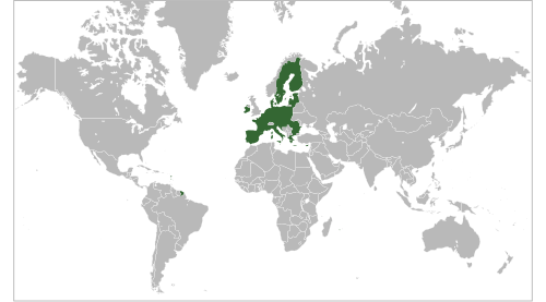


![Location of Metropolitan France (dark green) – in Europe (green & dark grey) – in the European Union (green) — [Legend]](https://upload.wikimedia.org/wikipedia/commons/thumb/a/a3/EU-France.svg/500px-EU-France.svg.png)
![Location of Metropolitan France (dark green) – in Europe (green & dark grey) – in the European Union (green) — [Legend]](https://upload.wikimedia.org/wikipedia/commons/thumb/a/a3/EU-France.svg/250px-EU-France.svg.png)


