Xanita: Difference between revisions
Jump to navigation
Jump to search
Created page with "{{Infobox state <!-- See Template:Infobox settlement for additional fields and descriptions --> | name = State of Xanita | native_name = | nati..." |
No edit summary |
||
| Line 44: | Line 44: | ||
| elevation_m = | | elevation_m = | ||
| population_footnotes = | | population_footnotes = | ||
| population_total = | | population_total = 10,085,314 | ||
| population_as_of = | | population_as_of = 2013 | ||
| population_est = | | population_est = | ||
| pop_est_as_of = | | pop_est_as_of = | ||
| Line 88: | Line 88: | ||
|2000|9120372 | |2000|9120372 | ||
|2010|9504577 | |2010|9504577 | ||
| | |2013|10085314 | ||
|2020?| | |2020?|10950000 | ||
}} | }} | ||
Latest revision as of 01:15, 17 October 2014
| State of Xanita | ||
|---|---|---|
| State | ||
| ||
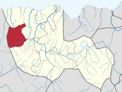
 Location of Xanita in Tikata | ||
| Country | ||
| Capital and Largest City | Turzy | |
| Government | ||
| • Governor | Udo Lamere | |
| Area | ||
| • Total | 33,764 km2 (13,036 sq mi) | |
| Area rank | 6th | |
| Population (2013) | ||
| • Total | 10,085,314 | |
| • Rank | 2nd | |
| • Density | 300/km2 (770/sq mi) | |
| • Density rank | 2nd | |
| Demonym(s) | Xanitian | |
Xanita is one of the 9 states of Tikata, located in the west of the country, bordered on the north and east by Surmetia state, on the south by Morsa, and on the west by the Republic of Pebbleland.
The state is famous for its natural beauty, and is a major destination for domestic and international tourism. The Lowra lowlands cover 5 municipalities and presents an enormous variety of flora and fauna, with forests, natural sand banks, savannahs, open pasture, fields and bushes. The city Crumeta, has prehistoric caverns, natural rivers, waterfalls, swimming pools and the Blue Lake cavern.
| Historical population | ||
|---|---|---|
| Year | Pop. | ±% |
| 1990 | 8,701,239 | — |
| 2000 | 9,120,372 | +4.8% |
| 2010 | 9,504,577 | +4.2% |
| 2013 | 10,085,314 | +6.1% |
| 2020? | 10,950,000 | +8.6% |

