Gandhara: Difference between revisions
| Line 160: | Line 160: | ||
The landscape is dominated by rugged [[Wikipedia:Mountain_range|mountain ranges]], [[Wikipedia:Desert|desert]] basins, and, in the eastern part of the country, dense rain forests. Despite having numerous rivers and reservoirs, large parts of the country are dry. It is a very mountainous country, with the Hare Krishna mountain range, that extends north to south across the country, and contains Outernatia's highest point, [[Mount Taysir]], at 5,769 m (18,927 ft). | The landscape is dominated by rugged [[Wikipedia:Mountain_range|mountain ranges]], [[Wikipedia:Desert|desert]] basins, and, in the eastern part of the country, dense rain forests. Despite having numerous rivers and reservoirs, large parts of the country are dry. It is a very mountainous country, with the Hare Krishna mountain range, that extends north to south across the country, and contains Outernatia's highest point, [[Mount Taysir]], at 5,769 m (18,927 ft). | ||
Gandhara shares terrestrial borders with seven other countries | Gandhara shares terrestrial borders with seven other countries. The countries are listed below (listed anti-clockwise around Gandhara). | ||
{| class="wikitable sortable" | |||
!Country | |||
!Length | |||
|- | |||
|{{flag|Lettuce}}||302 km (188 mi) | |||
|- | |||
|{{flag|Raingate}}||944 km (587 mi) | |||
|- | |||
|{{flag|Frostfall}}||313 km (194 mi) | |||
|- | |||
|{{flag|Almarania}}||364 km (226 mi) | |||
|- | |||
|{{flag|Folkloria}}||988 km (614 mi) | |||
|- | |||
|{{flag|Sofós}}||593 km (368 mi) | |||
|- | |||
|{{flag|Zelmerlöwia}}||902 km (560 mi) | |||
|} | |||
===Climate=== | ===Climate=== | ||
Revision as of 22:30, 11 January 2016
Arab Republic of Gandhara
| |
|---|---|
Motto: بالله نثق (Arabic) In God we trust | |
Anthem: ترنيمة من الغانذاري (Arabic) Hymn of the Gandhari | |
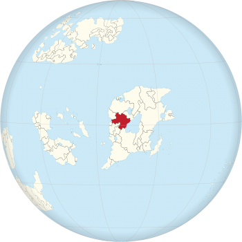 Location of Gandhara (red) | |
| Capital | Rhea |
| Largest city | Manas |
| Official languages | Arabic |
| Recognised regional languages | |
| Ethnic groups | |
| Demonym | Gandhari |
| Government | Unitary semi-presidential republic |
| Yasser Thunayan | |
• Prime Minister | Ahmad Jamil Bhatti |
| Legislature | Parliament |
| Senate | |
| National Assembly | |
| Establishment | |
| 15 January 1957 | |
| 4 October 1957 | |
• Republic declared | 10 December 1957 |
| Area | |
• Gandhara[note 1] | 674,463 km2 (260,412 sq mi) (18th) |
• Asabiya | 69,226 km2 26,728 sq mi |
• Diyafa | 50,218 km2 19,389 sq mi |
| Population | |
• 2015 estimate | 32,225,842 |
• Asabiya | 5,313,729 |
• Diyafa | 3,361,449 |
• Density (Gandhara) | 47.78/km2 (123.7/sq mi) |
| Currency | Gandhari dinar (GAD) |
| Time zone | GST (UTC+9) |
| Date format | DD/MM/YYYY |
| Drives on the | right |
| Calling code | +969 |
| Internet TLD | .ga غانذارا. |
Gandhara (Arabic: غانذارا, Gāndhāra), officially the Arab Republic of Gandhara (Arabic: جمهورية غانذارا العربية, Jumhūriyyat Gāndhāra al-ʿArabiyyah), is a country located in Outernatia. It is bordered by Lettuce and the Artemitic Sea in the west, by Zelmerlöwia in the northwest, by Sofós in the north, by Folkloria in the east, by the Nuran Sea in the southeast, by Almarania in the south, and by Frostfall and Raingate in the southwest. The country also holds sovereignty over the archipelagos of Asabiya and Diyafa, both autonomous republics with their own regional governments. Gandhara has a population of around 32 million people and its territory covers 674,463 km² (260,412 sq mi). Its capital Rhea is among the oldest continuously-inhabited cities in the world.
The modern Gandhari state was established after the Gandhari Revolution, which led to the establishment of an Arab Republic on 10 December 1957. The President of Gandhara is Yasser Thunayan since 4 September 2004. Gandhara is a founding member of the Outernatian Union and the Union of Sovereign States.
Modern Gandhara is considered to be a regional and middle power, with significant cultural, political, and military influence in Outernatia and the Muslim world. Its economy is one of the largest and most diversified in Outernatia, and its extensive mineral and energy resources have made it one of the largest producers of oil and natural gas globally. While the capital Rhea is the political center, the city of Manas is considered the economic and business center of Gandhara. The national currency is the Gandhari dinar, and Arabic is the official language.
Etymology
The country's name derives from the ancient kingdom Gāndhāra (Sanskrit: गन्धार), that lasted from the Vedic period (ca.1750–500 BCE). The kingdom was located in modern day Sadat. The origin of the name is not certain, but it has been suggested that it originates from the Sanskrit word gandha, meaning perfume, referring to the spices and aromatic herbs which the inhabitants of the ancient kingdom traded and with which they anointed themselves.[1]
History
Mustafa dynasty

At the beginning of the 1500s, modern day Gandhara was divided into a patchwork of independent, mostly Arab states. Emir Shamal Mustafa of Sadat conquered Wakra in 1522. Several tribes opposed the Emir's rule and a period of civil war and turmoil began, after which Shamal Mustafa defeated most of his opponents. In 1530 Mustafa adopted the title of sultan and founded the Sultanate of Gandhara.
After the death of Mustafa in 1535, his son Mustafa II, also known as Mustafa the Conqueror, ascended the throne. Under Mustafa II, Gandhara entered a period of expansion. The Sultanate prospered under the rule of the committed and effective Sultan. It also flourished economically due to its control of the major overland trade routes of east Outernatia.
Mustafa II expanded the northern frontier of the Sultanate by defeating Sofosian tribes in 1537. It was Mustafa's dream to reach the western coast to create a naval presence on the sea and he attacked the New Kingdom of Lettuce (Spanish: Nuevo Reino de Lettuce), a colony of the Spanish Emire, in 1538. It was the start of the Gandhari–Spanish War that lasted for 23 years, until Spain was defeated during the Battle of Shibam in 1561.
Emergence of an Empire
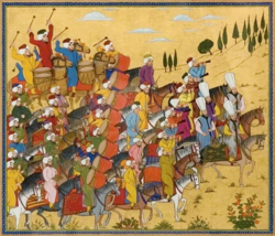
Gandhara grew rapidly during the second half of the 16th century. The Dabbagh (1565) and Umayyah Caliphate (1571) were added to the Gandhari territory. After the defeat of Kurdish tribes in 1575, the Gandhari Empire expanded further to the north. After the death of Mustafa II in 1577, his son Mustafa III conquered more lands, expanding Gandhara to the southeast and south. In 1592, Gandhari soldiers reached the coast of the Nuran Sea.
Neighbouring empires saw the Gandhari Empire as a serious threat, and in 1594 soldiers of the Almaranian Empire attacked the southern provinces of Gandhara. It was the start of the first Almaranian–Gandhari War that lasted until 1603, and ended with a stalemate with varying fronts between the Almaranian and Gandhari forces. A second conflict between the two empires started in 1615 and lasted until 1628, with a victory of Gandhara. Important areas of Almarania, including the Mavrija region, were ceded to Gandhara.
After this Gandhari expansion, a competition started between the Gandhari Empire and the Kingdom of V to become the dominant power in the region. Three wars have been fought between the two states during the 17th century. The last war, the Gandhari–V War of 1683–1699, ended with the Treaty of Sayed, a peace treaty in which Gandhara and V divided the areas between the states.
Gandhari Golden Age
The Treaty of Sayed started a period that became known in Gandhara as the Golden Age. The 18th century became a period in which Gandhari trade, science, military, and art were among the most acclaimed in the world. During its Golden Age, the Sultanate became one of the largest kingdoms of Outernatia, stretching from modern-day Lettuce, to Xara Khanate and Monteverde, and from the southern part of modern-day Sofós, to the borders of Háttųka and V. Its army was able to defend the empire against numerous invasions. The country prospered thanks to its enormous exports.
The Golden Age lasted until the 19th century. The year 1822 is considered by historians as the turning point in the hegemony of the Sultanate. Sultan Salman IV was defeated that year during the Battle of the Nuran Sea by a coalition of countries and as a result Gandhara lost important territories in the east.
The loss of the eastern territories and war expenses led to financial problems, which resulted in an economical and cultural downfall of the Sultanate. Further territories were lost during the Gandhari–Sofosian War of 1852–1859. This period in Gandhari history is also characterized by internal conflicts in which ethnic groups opposed the rule of the Sultan. Examples include the Umayyah Uprising (1865) and the Kurdish Rebellion (1869–1873). The Sultanate era finally ended with the death of Sultan Ebrahim V in 1878.
Al-Mansur dynasty

After the death of Sultan Ebrahim V, there was a short period of civil unrest in which Abbas al-Mansur, member of a prominent family, and an important military leader, ascended the throne. Abbas crowned himself Emir and found the Al-Mansur dynasty. Under Abbas al-Mansur, Gandhara experienced a revival of economic prosperity. It resisted efforts to be colonised, although the Emirate lost lands as a result of British and Russian empire-building, known as The Great Game.
The government during the Al-Mansur dynasty can be characterized as autocratic. The supreme power was concentrated in the hands of the Emir, whose decisions were subject to neither external legal restraints nor regularized mechanisms of popular control. Political opponents were imprisoned and the criminal justice system was dominated by arbitrariness. Abusive treatment and torture were often practiced and a range of offences were subject to the death penalty.
At the beginning of the 20th century, a demand for modernization of the Gandhari political structure was born. After the Russian Constitution and the Persian Constitution in 1906, the idea started to grow that Gandhara should turn into a constitutional monarchy. Another point of criticism was the fact that the government granted economic privileges to the United Kingdom and France. The Al-Mansur family saw Western European powers as important allies, and therefore Emir Rahimullah al-Mansur granted their ships free access to the main harbours and he gave several fiscal privileges to English and French companies. Inspired by the Russian Revolution of 1917, a wave of mass political and social unrest spread through vast areas of Gandhara during the spring of 1918. This became known as the Constitutional Revolution of Gandhara.
During the Constitutional Revolution, the Gandhari army managed to stop the opposition, but the Emir implemented reforms with the Gandhari Constitution of 1919. The Constitution set up a multiparty system and a limited constitutional monarchy. The Emir would share his autocratic power with a bicameral parliament, but he retained an absolute veto over legislation, as well as the right to dismiss the parliament at any time.
Republic
After the discovery of significant oil reserves in the early 1950s and the subsequent income from petroleum sales, Gandhara was able to transition to a wealthy state. Oil and petroleum improved the government's finances, but the nation's wealth was concentrated in the hands of Emir Mohamed al-Mansur. Several movements promoted the view that the government was corrupt and that Gandhara would become a pro-Western puppet state. This discontent mounted with the rise of Arab nationalism/socialism throughout the country.
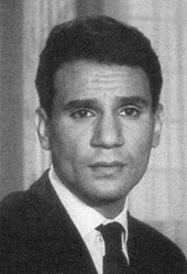
As a response to the growing Arab nationalism, the Arab Socialist Union of Gandhara was established in 1952 by four military officers of the Gandhari army. The movement was originally founded as a nationalist movement, in order to promote Arab nationalism, but the military strength of the organization increased during the early years, which led to distrust of the organization by the government. The Gandhari government tried to prohibit the Arab Socialist Union several times, but the movement received support from conservative political parties.
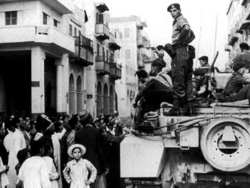
On 28 September 1956, 23 people were killed during a demonstration in Port Eden. Major riots throughout Gandhara followed, and the Arab Socialist Union managed to take control over several parts of Port Eden. This is considered to be the start of the Gandhari Revolution, in which the Arab Socialist Union overthrew the Al-Mansur dynasty. On 15 January 1957, when soldiers of the Arab Socialist Union defeated royalist supporters around Rhea and managed to capture the capital city, Emir Mohamed al-Mansur left the city with his family and his personal staff, and the Union installed a provisional government the same day. After being deposed, the Emir fled to Egypt, and later travelled to Switzerland, where he died. Today, most descendants of the Al-Mansur family live in Europe, mainly Switzerland and France.
After the adoption of a new Constitution on 4 October 1957, the Arab Republic was established on 10 December of that same year. Ahmed Assiri, leader of the Union during the revolution, became the first President of Gandhara. As a result of the revolution, the Lettuce Governorate proclaimed the Lettucian independence as the First Lettucian Republic. The independence was formalized on 15 August 1957 with the Lettucian Independence Act, and formally recognized by Gandhara on 14 May 1958 by the Treaty of Vola.
Geography
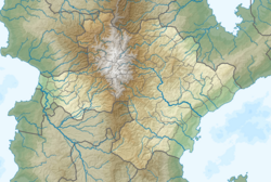
Gandhara is located in eastern Outernatia. The country lies between latitudes 6°N and 3°S, and longitudes 127° and 137°E. It straddles the Equator, with 86% to the North and 14% to the South. The territory covers 674,463 km² (260,412 sq mi).
The landscape is dominated by rugged mountain ranges, desert basins, and, in the eastern part of the country, dense rain forests. Despite having numerous rivers and reservoirs, large parts of the country are dry. It is a very mountainous country, with the Hare Krishna mountain range, that extends north to south across the country, and contains Outernatia's highest point, Mount Taysir, at 5,769 m (18,927 ft).
Gandhara shares terrestrial borders with seven other countries. The countries are listed below (listed anti-clockwise around Gandhara).
| Country | Length |
|---|---|
| 302 km (188 mi) | |
| 944 km (587 mi) | |
| 313 km (194 mi) | |
| 364 km (226 mi) | |
| 988 km (614 mi) | |
| 593 km (368 mi) | |
| 902 km (560 mi) |
Climate
The climate of Gandhara varies due to its geographical size. The largest part of the country has an arid or semi-arid climate, while the western and northern edge, and the eastern and southern part of the country have a subtropical climate.
High-lying areas can have harsh winters, with an average temperature in January below −15 °C (5 °F), while the low-lying areas have hot summers, where average summer temperatures exceed 38 °C (100.4 °F).
Politics
Governance
According to the Constitution of Gandhara, the country is a unitary semi-presidential republic, wherein the President is the head of state and the Prime Minister is the head of government. The current constitution was adopted on 4 October 1957, and came into force on 13 November the same year. The Arab Republic of Gandhara is fundamentally structured as a multi-party representative democracy, with the central government composed of three branches:
- Legislative: The bicameral Parliament of Gandhara, made up of the 240-member National Assembly and the 96-member Senate. The National Assembly has the power to pass with a simple majority a motion of no confidence against the Government of Gandhara, in which case the President can choose to dismiss the cabinet, or dissolve the National Assembly and call for new general elections. The National Assembly proposes legislation, discusses proposed legislation, and reviews actions of the cabinet. If proposed legislation is adopted, the bill is sent to the Senate. After a study, the bill will be passed if adopted by a majority, or sent back to the National Assembly. If a bill is rejected, the National Assembly has the possibility to amend the bill and send it to the Senate again. The cabinet has the right to propose legislation as well, but only the National Assembly can discuss and amend proposed legislation. The Senate itself cannot propose legislation. The 240 members of the National Assembly, the lower house, are elected in direct elections on the basis of party-list proportional representation. These are held every four years, or sooner in case the cabinet falls. The 96 members of the Senate, the upper house, are elected for two-thirds (64 members) by elected local councils, and are appointed for one-third (32 members) by the President of Gandhara. Every first-level administrative division of Gandhara is represented by three Senators in the Senate. The Senators are chosen for 4-year terms as well.
- Executive: The President is the supreme commander of the armed forces and head of the executive branch of the Gandhari government. The cabinet is the highest executive and administrative body. It consists of the Prime Minister and the ministers. According to the constitution, the ministers are responsible to the president.
- Judiciary: The Supreme Court, whose judges are appointed by the Senate on the recommendation of the President, interpret laws and overturn those they find unconstitutional.
The president is directly elected by universal suffrage for a 7-year term. Since the revision of the constitution in 1990, a president cannot serve more than two consecutive terms. Ministries of the government are composed of the Premier and his deputies, ministers, and selected other individuals; all are appointed by the President on the recommendation of the Prime Minister (whereas the appointment of the latter requires the consent of the National Assembly). Leading political parties are the Arab Party for Justice and Equality and the Republican People's Party, who have a majority in the National Assembly (126 seats out of 240) and the Senate (57 seats out of 96).
Administrative divisions
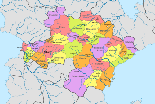
Gandhara is divided into thirty governorates. Two overseas territories, Asabiya and Diyafa, are governed as autonomous republics, and are on the same level as the governorates.
- Governorates
Each governorate is governed by a governor, who is appointed by the President of Gandhara. The governorates are further divided into 351 districts, each of which is subdivided into subdistricts. Districts and subdistricts are administered by officials appointed by the governor, subject to the approval of the interior minister. These officials work on local matters with elected district councils and serve as intermediaries between the central government and local leaders.
|
|
- Autonomous republics
The archipelagos of Asabiya and Diyafa are governed as autonomous republics, and are first-level administrative divisions. They are autonomous after the central government delegated political powers through devolution to the local governments of the republics by statute. Both island groups exercise their right to self-government within the limits set forth in the constitution and their autonomous statutes.
Demographics
Gandhara is a diverse country, consisting of different religious and ethnic groups that are unified through a shared Arab language and culture. The Gandhari people are the largest ethnic group of the country. Other major ethnic groups are the Kurdish and Baloch people, accounting for almost 23% of the total population.
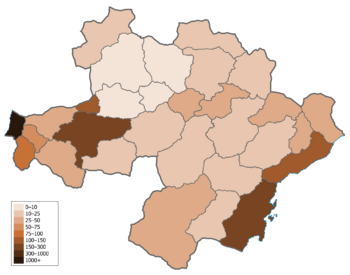
As of 2015, the population of Gandhara is around 32,225,842. In 1950, the population was reported to be about 20.5 million. There are three cities with over a million residents: Manas, the capital Rhea, and Kazmi. Population is densest along the coast of the Nuran Sea and in the western part of the country. The central and northern part of Gandhara are very sparsely populated, due to the dry and mountainous landscapes. In recent decades, many people moved from the rural areas to urban areas, which resulted in a rapid population growth in many cities. Besides big cities in the western and southeastern part of the country, the northeastern part attracted many workers and students in recent years, due to increased development in the region.
Gandhara's population grew rapidly during the latter half of the 20th century. This increase was due to a number of factors, including the lessening of the mortality rate and increased life expectancy by improved sanitation and medical advances, and a massive increase in agricultural productivity. However, Gandhara's birth rate has dropped significantly in recent years. The reason for this is that people are having children at an older age, and that families become smaller. Even though the birth rate is falling, it is expected that the population will continue to grow in upcoming years, mainly as a result of immigration from neighbouring countries.
Notes
- ^ The Arab Republic of Gandhara's territory in continental Outernatia is referred to as "Gandhara proper", "metropolitan Gandhara", or simply Gandhara. In this article, the usage of "Gandhara" excludes Asabiya and Diyafa.
References
- ^ Thomas Watters (1904). "On Yuan Chwang's travels in India, 629–645 A.D.". Royal Asiatic Society. p. 200. "Taken as Gandhavat the name is explained as meaning hsiang-hsing or "scent-action" from the word gandha which means scent, small, perfume." At the Internet Archive.


