Laranjeirian Confederation: Difference between revisions
No edit summary |
No edit summary |
||
| Line 85: | Line 85: | ||
==Etymology== | ==Etymology== | ||
The country's name derives from the | The etymology is unknow. Some investigators says that the country's name derives from the first family that ruled the kingdom,the Laranjeiras Family. But, some say that this name comes from the orange (laranja,in [[latin_language|portuguese]]) orchard that exists in the city of Pomar. Though the first theory is the most accepted,the second one makes sense too. | ||
==History== | ==History== | ||
Revision as of 02:13, 18 June 2015
Confederative Republic of Laranjeiras | |
|---|---|
Motto: Braços Fortes,Mãos Amigas. (Latin) Strong Arms,Friendly Hands. | |
Anthem: Laranjeiras,Pátria Mãe! (Portuguese) Laranjeiras,Motherland! | |
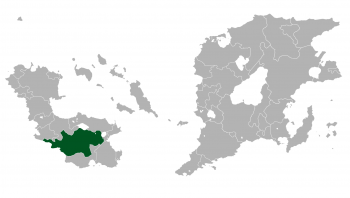
 Location of RC Laranjeiras in Outernatia | |
| Capital and largest city | Pomar |
| Official languages | Portuguese and Laranjeirian |
| Recognised national languages | Portuguese and Laranjeirian |
| Recognised regional languages | Portuguese and Laranjeirian |
| Ethnic groups |
|
| Demonym | Laranjeirian |
| Government | Federal presidential republic |
| Victor Ramsés | |
• Vice-President | Igor Teles |
• Chairman of Parliament | Brenno Gulard |
| Area | |
• Total | 961,907 km2 (371,394 sq mi) |
| Population | |
• 2014 estimate | 200,004,000 |
• Density | 40.2/km2 (104.1/sq mi) |
| HDI (2014) | 0.930 very high |
| Currency | Laranjeirian Real (L$) |
| Date format | DD/MM/YYYY |
| Drives on the | left |
| Calling code | 71 |
| Internet TLD | .la |
Laranjeiras (Laranjeirian: Laranjeiras, Portuguese: Laranjeiras), officially the Confederative Republic Of Laranjeiras or Laranjeirian Confederation is a country in the southwestern part of Outernatia. Covering a territory of 961,907 km km2 it is among the biggest countries on the continent, bordering Auspikitan to the north, Ponásikwa to the northeast, Timivar to the southwest and Marvelia in the southeast. To the west lies the Western Ocean. Its capital is Pomar. It is divided into 4 regions and a submarine territory. As of 2014, the population of Laranjeiras accounts for 200,004,000 people.
The Laranjeirian statehood dates back to the 3th century with the Sulorian Confederation,that now corresponds to the countries of Laranjeiras and Hanzyuki. After a long past of alliance, Laranjeiras and Hanzyuki,along with some other countries created the Sulorian Confederation, a personal union between the two states, which became a major political factor in Internatia up until the 21th century. In the late 21th century the Confederation was partitioned between Republic of Hanzyuki, Nequalia,Laranjeiras and Republic of Javland, but after the civil war that succeded that partition,Nequalia and Javland were annexed by Laranjeiras.
As of now, Laranjeiras has a very high-income market economy, and scores "very high" on the Human Development Index. The abundance of natural resource,the rapidly growing economy and the very high HDI make some scholars to refer to Laranjeiras as a "Southwest Giant". It is a founding member of the Council of Outernatia.
Etymology
The etymology is unknow. Some investigators says that the country's name derives from the first family that ruled the kingdom,the Laranjeiras Family. But, some say that this name comes from the orange (laranja,in portuguese) orchard that exists in the city of Pomar. Though the first theory is the most accepted,the second one makes sense too.
History
Sulorian Confederacy

At the beginning of the third century before christ, due to the crescent invasion made by the barbarians, several independent kingdoms decided to
After the death of Mustafa in 1535, his son Mustafa II, also known as Mustafa the Conqueror, ascended the throne. Under Mustafa II, Gandhara entered a period of expansion. The Sultanate prospered under the rule of the committed and effective Sultan. It also flourished economically due to its control of the major overland trade routes of east Outernatia.
Mustafa II expanded the northern frontier of the Sultanate by defeating Dalmadrian tribes in 1537. It was Mustafa's dream to reach the western coast to create a naval presence on the sea and he attacked the New Kingdom of Lettuce (Spanish: Nuevo Reino de Lettuce), a colony of the Spanish Emire, in 1538. It was the start of the Gandhari-Spanish War that lasted for 23 years, until Spain was defeated during the Battle of Shibam in 1561.
Administrative divisions
States
| Flag | State | Capital | Area | Population |
|---|---|---|---|---|
| Distrito Confederal de Pomar | Pomar | 3,303 km2 | 73,400 | |
| Gale Port | Porto da Ventania | 94,207 km2 | 73,400 | |
| Campina Luminosa | Campina Luminosa | 126,560 km2 | 4,214,503 | |
| Campo da Bravura | Campo da Bravura | 123,837 km2 | 9,795,819 | |
| Hippocampus | Hippocampus | 27,811 km2 | 4,385,992 |
Cities
| Rank | Regions of Laranjeiras | Pop. | |||||||
|---|---|---|---|---|---|---|---|---|---|
 Pomar  Porto da Ventania |
1 | Pomar | Special status | 20,935,204 |  Campo da Bravura Campina Luminosa | ||||
| 2 | Porto da Ventania | Porto da Ventania | 11,973,505 | ||||||
| 3 | Campo da Bravura | Campo da Bravura | 5,767,414 | ||||||
| 4 | Campina Luminosa | Campina Luminosa | 4,161,237 | ||||||
| 5 | Cervinho | Porto da Ventania | 4,118,154 | ||||||
| 6 | Sales | Distrito Confederal de Pomar | 3,919,864 | ||||||
| 7 | Taquara | Campina Luminosa | 3,887,261 | ||||||
| 8 | Mineralina | Porto da Ventania | 3,818,380 | ||||||
| 9 | Armenta | Campo da Bravura | 3,414,115 | ||||||
| 10 | Hippocampus | Hippocampus | 3,043,217 | ||||||


