San Remo: Difference between revisions

From escforumwiki
Jump to navigation Jump to search
No edit summary
No edit summary
 
(47 intermediate revisions by 2 users not shown)
Line 1: Line 1:
{{Infobox country
{{Infobox country
|native_name                = República de San Remo <small>([[Wikipedia:Spanish_language|Spanish]])</small> <br> República de Sanremo <small>([[Wikipedia:Portuguese_language|Portuguese]])</small>
|native_name                =  
|conventional_long_name      = Republic of San Remo
|conventional_long_name      = San Remo
|common_name                = San Remo
|common_name                = San Remo
|image_flag                  = Flag of San Remo.png
|image_flag                  = Flag of San Remo.png
|image_coat                  = Coat of arms of San Remo.png
|image_coat                  = Coat of arms of San Remo.png
|symbol_type                = Coat of arms
|symbol_type                = Coat of arms
|national_motto              = "Deus lo vult" (Latin) <br><small>''God wants it''</small>  
|national_motto              = "Deus lo vult" ([[Wikipedia:Latin_language|Latin]])<br><small>''God wants it''</small>  
|national_anthem            =
|national_anthem            =
|image_map                  = San Remo map.png
|image_map                  = Location San Remo.png
|map_caption                = Location of San Remo
|image_map2                  = Archipelago San Remo.png
|capital                    = Rhea
|map_caption                = Location of '''San Remo''' (orange)
|map_caption2                = '''San Remo''' (orange)
|capital                    = [[Rhea]]
|largest_city = capital
|largest_city = capital
|official_languages          = [[Wikipedia:Spanish_language|Spanish]], [[Wikipedia:Portuguese_language|Portuguese]], [[Wikipedia:Latin|Latin]]
|official_languages          = [[Romi]], [[Tikatan]]
|national_languages          =  
|national_languages          =  
|demonym                    = San Remano/a
|demonym                    = San Reman
|government_type            = [[Wikipedia:Unitary_state|Unitary]] [[Wikipedia:Presidential_system|presidential]] [[Wikipedia:Constitutional_republic|constitutional republic]]
|government_type            = [[Wikipedia:Unitary_state|Unitary]] [[Wikipedia:Parliamentary_system|parliamentary]] [[Wikipedia:Constitutional_monarchy|constitutional monarchy]]
|leader_title1              = President
|leader_title1              = Monarch
|leader_name1                = Juan García Aragón
|leader_name1                = [[Michael_II_of_Tikata|Michael II]]
|leader_title2              = Vice President
|leader_title2              = Governor-General
|leader_name2                = Horacio Domingo Elizondo
|leader_name2                = Horacio Domingo Elizondo
|leader_title3              = Prime Minister
|leader_name3                = Juan García Aragón
|sovereignty_type            =  
|sovereignty_type            =  
|established_event1          = Independence from [[Wikipedia:Spain|Spain]]
|established_event1          =  
|established_date1          = 19 February 1785
|established_date1          =  
|established_event2          = Republic
|established_event2          =  
|established_date2          = 5 July 1889
|established_date2          =  
|established_event3          =
|established_event3          =  
|established_date3          =
|established_date3          =  
|established_event4          =
|established_event4          =
|established_date4          =
|established_date4          =
Line 32: Line 36:
|established_date9          =
|established_date9          =
|area                        = <!-- major area size (in [[Template:convert]] either km2 or sqmi first) -->
|area                        = <!-- major area size (in [[Template:convert]] either km2 or sqmi first) -->
|area_km2                    = <!-- major area size (in square km) --> 111296
|area_km2                    = 495807
|area_sq_mi                  = <!-- area in square mi (requires area_km2) -->
|area_sq_mi                  = <!-- area in square mi (requires area_km2) -->
|population_estimate        = 10,267,340
|area_label                  = Total
|population_estimate        = 50,371,809
|population_estimate_rank    =
|population_estimate_rank    =
|population_estimate_year    = 2013
|population_estimate_year    = 2014
|population_census          =  
|population_census          =  
|population_census_year      =  
|population_census_year      =  
|population_density_km2      = 92.3
|population_density_km2      = 101.60
|population_density_sq_mi    =  
|population_density_sq_mi    =
|GDP_PPP                    =  
|GDP_PPP                    =  
|GDP_PPP_rank                =  
|GDP_PPP_rank                =  
Line 54: Line 59:
|HDI_year                    =  
|HDI_year                    =  
|HDI_category                =  
|HDI_category                =  
|currency                    = Peso
|currency                    = [[Aleta]]
|currency_code              = COP
|currency_code              = SRA
|time_zone                  =  
|time_zone                  =  
|utc_offset                  =  
|utc_offset                  =  
|time_zone_DST              =  
|time_zone_DST              =  
|utc_offset_DST              =  
|utc_offset_DST              =  
|broadcaster                = RTVR (Radio y Televisión San Remano)
|broadcaster                = FRS (Fundación de Radiodifusión San Remana)
|date_format                = DD/MM/YYYY
|date_format                = DD/MM/YYYY
|drives_on                  = Right
|drives_on                  = Right
|cctld                      = .sr
|cctld                      = .sr
|calling_code                =  
|calling_code                = 345
|}}
|}}


San Remo, officially the '''Republic of San Remo''', is a sovereign state, located on the northern continent of Internatia. The capital is Rhea, the largest city of the country by both land area and population. San Remo is bordered by [[Sockistan]] to the northwest, [[Anselmsuusonia]] to the east, [[Kosma]] to the southeast and by the sea to the north and the southwest.<br>
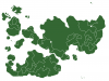
'''San Remo''' ([[Romi]]: ''Sanremo'', [[Tikatan]]: ''Sant'xa Remarz'') is an [[Wikipedia:Island_country|island country]]. The country geographically comprises two main landmasses and several smaller islands.


== History ==
San Remo gained independence from the [[Tikata|Kingdom of Tikata]] in 1814. A new [[Wikipedia:Constitution|constitution]] was adopted on 6 January 1815. The western part of Carbalia, the second largest island of San Remo, has been under the ''[[Wikipedia:De_facto|de facto]]'' control of the breakaway government of [[Colinestria]] since 1 September 2013.


===Pre-San Remo===
Nationally, legislative authority is vested in an elected, unicameral parliament, while executive political power is exercised by the cabinet, led by the [[Wikipedia:Prime_minister|Prime Minister]], who is currently Juan García Aragón. King [[Michael_II_of_Tikata|Michael II]] is the country's head of state and is represented by a [[Wikipedia:Governor-General|Governor-General]]. In addition, San Remo is organised into 15 regional councils and 67 provinces for local government purposes. San Remo is a member of the [[Commonwealth of Nations]].
 
San Remo was already inhabited in 10,000 BC. It was a part of the [[Wikipedia:Roman_Empire|Roman Empire]] during the [[Wikipedia:Ancient_Rome|ancient Roman civilization]] and it existed of different kingdoms during the [[Wikipedia:Middle_Ages|Middle Ages]]. An important city was San Remo, founded on [[Wikipedia:August_13|13 August]] [[Wikipedia:489|489]] and named after [[Wikipedia:St._Remigius|St. Remigius]].
 
===Republic of San Remo===
 
After Portuguese and Spanish domination, San Remo became independent on [[Wikipedia:February_19|19 February]] [[Wikipedia:1785|1785]]. Radboud I became king of the Kingdom of San Remo ([[Wikipedia:Spanish_language|Spanish]]: ''Reino de San Remo''; [[Wikipedia:Portuguese_language|Portuguese]]: ''Reino de Sanremo'').
 
In [[Wikipedia:1889|1889]] king Ferdinand II of San Remo abdicated the throne and San Remo became a [[Wikipedia:Republic|republic]] on [[Wikipedia:July_5|5 July]] [[Wikipedia:1889|1889]].
 
== Government ==
 
===Administrative divisions===
 
San Remo is divided into 13 departments ([[Wikipedia:Spanish language|Spanish]]: ''departamentos'', sing. ''[[Wikipedia:Departamento|departamento]]'').
 
{| class="wikitable"
|-
| rowspan="14" align="center" | [[File:San remo map2.png|400px]]
|-
! Flag
! Name
! Capital
|-
|[[File:AlmeidaFlag.png|30px]]
|Almeida
|Vila Nova
|-
|[[File:AmadoraFlag.png|30px]]
|Amadora
|Sanremo (San Remo)
|-
|[[File:AstraliaFlag.png|30px]]
|Astralia
|Santo António
|-
|[[File:BoyacáFlag.png|30px]]
|Boyacá
|Florencia
|-
|[[File:CosmaFlag.png|30px]]
|Cosma del Oeste
|Agustín
|-
|[[File:GondomarFlag.png|30px]]
|Gondomar
|Vila Franca
|-
|[[File:LeónFlag.png|30px]]
|León
|Rhea
|-
|[[File:MontoyáFlag.png|30px]]
|Montoyá
|Atlántico
|-
|[[File:PenedesFlag.png|30px]]
|Penedés
|Las Cabanas
|}
 
== Demographics ==
 
{{Location mark+
| image = San Remo location map.png
| width = 600
| caption = San Remo
| type = thumb
| marks =
{{Location mark~
  | width = 600
  | label = <u>Rhea</u>
  | position = bottom
  | background =
  | x = 498 | y = 507 }}
{{Location mark~
  | width = 600
  | label = Sanremo
  | position =
  | background =
  | x = 181 | y = 725 }}
{{Location mark~
  | width = 600
  | label = Santo António
  | position =
  | background =
  | x = 64 | y = 625 }}
{{Location mark~
  | width = 600
  | label = Vila Franca
  | position =
  | background =
  | x = 263 | y = 381 }}
{{Location mark~
  | width = 600
  | label = Vila Nova
  | position = left
  | background =
  | x = 426 | y = 311 }}
{{Location mark~
  | width = 600
  | label = Medea
  | position = top
  | background =
  | x = 500 | y = 317 }}
{{Location mark~
  | width = 600
  | label = Atlántico
  | position =
  | background =
  | x = 484 | y = 69 }}
{{Location mark~
  | width = 600
  | label = San Alfonso
  | position =
  | background =
  | x = 585 | y = 186 }}
{{Location mark~
  | width = 600
  | label = Vila Nova
  | position = left
  | background =
  | x = 426 | y = 311 }}
{{Location mark~
  | width = 600
  | label = Florencia
  | position = top
  | background =
  | x = 491 | y = 209 }}
{{Location mark~
  | width = 600
  | label = Zanzibar
  | position = left
  | background =
  | x = 390 | y = 160 }}
{{Location mark~
  | width = 600
  | label = Guelaya
  | position =
  | background =
  | x = 553 | y = 348 }}
{{Location mark~
  | width = 600
  | label = Las Cabanas
  | position = bottom
  | background =
  | x = 734 | y = 338 }}
{{Location mark~
  | width = 600
  | label = Agustín
  | position = top
  | background =
  | x = 698 | y = 501 }}
}}
 
== Sport ==
 
===Football===
 
[[Wikipedia:Association_football|Football]] is the most popular [[Wikipedia:Sport|sport]] in San Remo. Both the men's and the women's national team compete in the Internatian Games.
 
===Other===
 
Other popular sports in San Remo are [[Wikipedia:Cycling|cycling]], [[Wikipedia:Athletics_(sport)|athletics]], [[Wikipedia:Boxing|boxing]], [[Wikipedia:Field_hockey|field hockey]] and [[Wikipedia:Swimming_(sport)|swimming]].
 
==Internatian Games==
 
San Remo sent athletes to the [[I Summer Internatian Games|first Internatian Games]] in Madakia, [[Tikata]]. The first San Reman medal ever was won by cyclist Lieuwe Westra in the ''Men's road time trial''.
 
===List of medalists===
{| class="wikitable"
|- style="text-align: center; background: #eee"
!style="width:5em"| Medal
!style="width:15em"| Name
!style="width:15em"| Games
!style="width:15em"| Sport
!style="width:15em"| Event
|-
|[[File:Gold medal icon.png]] Gold
|Lieuwe Westra
|[[File:Flag of Tikata.png|22px]] I Madakia
|[[File:Cycling (road) pictogram.png]] Cycling
|Men's road time trial
|-
|[[File:Bronze medal icon.png]] Bronze
|Marianne Vos
|[[File:Flag of Tikata.png|22px]] I Madakia
|[[File:Cycling (road) pictogram.png]] Cycling
|Women's road race
|}
 
==San Remo in the Internatia Song Contest==
{{Main|San Remo in the Internatia Song Contest}}
 
San Remo made its debut in the [[Internatia Song Contest 8]]. San Remo's debut entry was [[Wikipedia:Beth_(singer)|Beth Rodergas]] with "La Luz", however it was not a successful debut for the country, with Beth coming second last in the second semi-final.


{{Countries of Internatia |state=collapsed}}
[[Category:Country]]
[[Category:Country]]
[[Category:Data]]
[[Category:San Remo]]
[[Category:San Remo]]

Latest revision as of 13:38, 9 October 2020

San Remo
Coat of arms of San Remo
Coat of arms
Motto: "Deus lo vult" (Latin)
God wants it
Location of San Remo (orange)
San Remo (orange)
San Remo (orange)
Capital
and largest city
Rhea
Official languagesRomi, Tikatan
DemonymSan Reman
GovernmentUnitary parliamentary constitutional monarchy
• Monarch
Michael II
• Governor-General
Horacio Domingo Elizondo
• Prime Minister
Juan García Aragón
Area
• Total
495,807 km2 (191,432 sq mi)
Population
• 2014 estimate
50,371,809
• Density
101.60/km2 (263.1/sq mi)
CurrencyAleta (SRA)
Date formatDD/MM/YYYY
Drives on theright
Calling code345
Internet TLD.sr

San Remo (Romi: Sanremo, Tikatan: Sant'xa Remarz) is an island country. The country geographically comprises two main landmasses and several smaller islands.

San Remo gained independence from the Kingdom of Tikata in 1814. A new constitution was adopted on 6 January 1815. The western part of Carbalia, the second largest island of San Remo, has been under the de facto control of the breakaway government of Colinestria since 1 September 2013.

Nationally, legislative authority is vested in an elected, unicameral parliament, while executive political power is exercised by the cabinet, led by the Prime Minister, who is currently Juan García Aragón. King Michael II is the country's head of state and is represented by a Governor-General. In addition, San Remo is organised into 15 regional councils and 67 provinces for local government purposes. San Remo is a member of the Commonwealth of Nations.